Tornado in Windsor, Colorado May 22, 2008
Published: May 28, 2008; Updated: February 9, 2009
During the late morning of 22 May 2008, thunderstorms formed north and east of the Denver Metro area and moved northward into northeast Colorado. Storm motion was actually west of due north, meaning storms forming in the climatologically favored region near Denver International Airport tracked toward the Urban Corridor of Colorado's Front Range (along and west of I-25), rather than a more typical eastward motion. One of the first storms of the day turned out to be the most intense, tracked over Windsor, Colorado, and produced a relatively intense tornado and large hail. The grand majority of tornaodes forming so close the Front Range are non-supercell tornadoes (or "landspouts"), and typically do little to no damage. This tornado has been rated EF-2 or EF-3 based on a damage survey completed by the National Weather Service Boulder office.
The two figures below show the 500 mb and surface analyses at 1800 UTC (noon local time) on 22 May. An intense closed 500 mb low was centered near Las Vegas, and a few notable jet streaks rotated around it. One such jet streak was located in Eastern Colorado, placing the northern Front Range in the favored left-exit region. At the surface, an extremely deep low was centered near Denver with relatively dry air south and east of it, and a tongue of moist air was being advected westward north of a roughly east/west-oriented boundary.

500 mb Heights (contours) and Wind Speed (colors) from the 1800 UTC NAM Analysis on 22 May 2008 (click to enlarge)

MSLP (contours), Surface Wind (wind barbs), and Surface Dew Point (colors) from the 1800 UTC NAM Analysis on 22 May 2008 (click to enlarge)
The GOES-12 Visible Loop (click the image below for the animation) clearly shows the boundary between dry air to the south and moist air to the north. As the moist air noses to the southwest toward the north side of Denver between 1400 - 1600 UTC, the stratus clouds just behind the boundary dissipate, allowing a narrow region to receive full sunlight. Clicking on the second image below shows an annotated visible image from 1615 UTC with the location of this boundary denoted with a black line. The storm of interest intiates just south of this boundary around 1645 UTC, and really blows up around 1700 UTC as it reaches the warm, moist air.

GOES-12 Visible Loop from 22 May 2008. (click for animation)

GOES-12 Visible image from 1615 UTC (click to enlarge)
The visible image below from 1745 UTC with surface observations shows the tornadic storm shortly before it has reached Windsor. Note the ob from Greeley: temperature of 70 F, dewpoint of 55 F, with 30 kt easterly winds gusting to 41. This provides the best estimate of the low-level air which the storm was ingesting. Taking the 18 UTC sounding from Denver and altering it with the Greeley surface data (and changing the low level temperature, moisture, and wind profiles to make them realisticially match the surface obs), we get the sounding shown below. Note the 2850 J/kg surface-based CAPE, and 256 m^2/s^2 0-1 km storm-relative helicity. Additionally, an LCL of only 1 km AGL is unusually low for Colorado.

GOES-12 Visible image from 1745 UTC and Surface Observations. The location of Windsor, Colorado, is shown with a red 'x'. (click to enlarge)

18 UTC Sounding from Denver modified with Greeley surface ob (click to enlarge)
Luckily, the Terra polar-orbiter made a pass directly over Colorado around 1800 UTC, allowing us to view MODIS imagery of the storm. Shown below are the Band 1 (visible) and Band 31 (IR) MODIS images. The 250-m resolution visible image shows incredible cloud detail, and the IR image shows evidence of a well-defined enhanced-V.

MODIS 250-m Visible image from 1800 UTC, stretched to increase contrast (click to enlarge)

MODIS 1-km Band 31 (Infrared) image from 1800 UTC (click to enlarge)
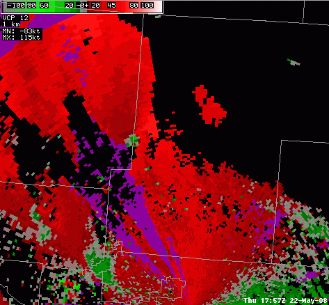
Below are links to the KFTG reflectivity and radial velocity loops. The Windsor storm forms right over Denver International Airport and quickly develops a hook echo and very large reflectivity values. The velocity loop shows a well-defined couplet as the storm progresses through Windsor.

KFTG 0.5 degree reflectivity from 1639 - 1827 UTC (click for animation)
KFTG 0.5 degree radial velocity from 1722 - 1801 UTC (click for animation)

Higher resolution KFTG 0.5 degree reflectivity from 1735 - 1744 UTC (click for animation); courtesy of NWS BOU

Higher resolution KFTG 0.5 degree storm relative radial velocity from 1735 - 1744 UTC (click for animation); courtesy of NWS BOU
The map below was provided courtesy of the Boulder Weather Forecast Office. It shows the locations and times of the reported tornadoes.

Map of tornado reports with times. Courtesy of Boulder WFO. (click to enlarge)

Map of tornado path.
It's also worth noting that the Colorado State University Main Campus Weather Station recorded its lowest pressure since Feb 25, 1998. At 1920 UTC on 22 May, the pressure bottomed out at 822.9 mb!
Brian McNoldy has put together a nice radar loop from KCYS: KCYS Radar Loop
A text listing of the severe weather warnings (severe thunderstorm and tornado) issued by the Boulder NWS on May 22, 2008 can be found here.
Below is a photo taken a few miles south of Wellington as the storm passed over I-25.

Photo of the storm taken a few miles south of Wellington (click to enlarge); courtesy of John Weaver
Some of the unusual aspects of this tornado caused us to look back at the climatology of tornadoes in Colorado, and particularly those very close to the Front Range, where much of Colorado's population resides. Below are a series of figures that show various aspects of Colorado and Wyoming tornadoes in the past. The data for these maps come from the "SVRGIS" database at the Indianapolis National Weather Service office, and is supplemented by historical data from Thomas Grazulis's book Significant Tornadoes 1680--1991. Also, on all of these maps, the track of the Windsor tornado of 22 May 2008 has been manually added to the database, based on the damage survey provided by the Boulder National Weather Service office.
We begin with a map showing all tornadoes in Colorado and Wyoming over the period 1950-2006, plus the Windsor tornado. (click to enlarge)

It is clear from this map that almost all tornadoes in Colorado and Wyoming occur east of the Continental Divide. There are some "long track" tornadoes, but most are small, short-lived tornadoes, indicated by tiny dots on this map.
Now, we narrow it down to significant tornadoes: those rated 2 or higher on the Fujita scale:

This map, when compared with the previous one, shows that only a small percentage of tornadoes in Colorado and Wyoming are rated F2 or higher -- just over 10%. Nationwide, this percentage is about 28%, which means that Colorado and Wyoming experience an even lower proportion of significant tornadoes than does the rest of the country. As with the total population of tornadoes, nearly all significant tornadoes are east of the Divide. It is also important to remember that the Fujita (and now Enhanced Fujita) scales rate tornadoes primarily on the damage they cause; therefore, storms affecting rural areas (where there is not much around to damage) are generally given low ratings. As such, significant tornadoes are found (artificially) more frequently in populated areas.
We now zoom in to look at tornadoes near the Front Range. Here, we limit the map to only show tornadoes occurring west of 104 W longitude (the Wyoming/Nebraska border).

Short-lived, weak tornadoes are quite common near the Front Range, with a few areas appearing to have "clusters", such as the areas just to the north and southeast of Denver International Airport. Weld County, with its huge size, also has a large number of tornadoes. An interesting aspect of the Windsor tornado was its track toward the northwest, and as a result we have highlighted all of the tornadoes with a component of motion toward the west in green to see how common such tracks are. It turns out that northwestward tracks have happened before, but make up only a very small minority of Front Range tornadoes. The Windsor tornado stands out as the longest green line on this map.
We now narrow this down further to look at only significant (rated F2 or higher) tornadoes near the Front Range.

On this map, we have also manually added some historical significant tornadoes along the Front Range, which are shown in blue. (The locations of these tracks are approximate, and were drawn in based on data in Grazulis's Significant Tornadoes.) This map shows that long-track, significant tornadoes do occur close to the Front Range, though they are not as common as in other parts of "Tornado Alley." In particular, Weld County has experienced numerous significant tornadoes over the years. Also, a few significant tornadoes in the past have had a westward component (shown in green), but most move toward the east.
We'll now zoom in a little further to look at significant tornadoes in and around Weld County.

It is clear from this map that western Weld County is not immune to strong, long-track tornadoes. This area has been hit several times in the past, though prior to the May 2008 storm, the last times the Windsor area experienced a significant tornado were in May 1957 and May 1952, and the last significant tornado anywhere in Weld County occurred in 1996. In addition to these, there were some destructive tornadoes in the past that are shown on the map in blue: an F3 tornado that began near Severance in 1920; an F4 tornado that hit Johnstown and killed two people in 1928; and a pair of F2 tornadoes on the same day in May 1943. The May 2008 Windsor tornado still stands out on this map because of its unusual northwestward track, as almost all of the other tracks shown on the map were either toward the northeast or the southeast.
A lot has changed about northern Colorado since these historical tornadoes took place, including a much larger population. This suggests that many residents of western Weld County had never experienced a significant tornado in the area prior to May 2008. The climatology shows that such events may be rare, but they are a real threat in northern Colorado.
Finally, another unusual aspect of the May 2008 Windsor tornado was the time of day at which it formed (approximately 11:26 AM Mountain time.) Below is a chart showing the time of day for significant tornadoes near the Front Range.

The large majority of tornadoes near the Front Range occur in the afternoon and evening, between 2 and 7 pm. The Windsor tornado occurred on the very early side of this distribution, though there have been a few other significant tornadoes in this area that have developed before noon.
Authors
Dan Lindsey, Jeff Braun, Brian McNoldy, Russ Schumacher