Observations of a Fast, Left-Moving Storm on 4 May 2003
Published: July 29, 2003
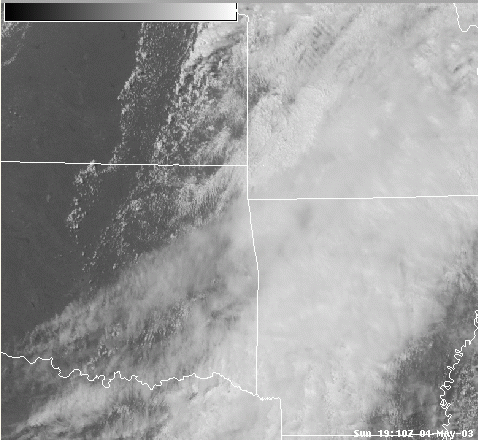
On May 4, 2003, a thunderstorm formed along a dry line in southeastern Oklahoma. It quickly split, and the left-mover traversed across Oklahoma before interacting with other supercells in northeastern Oklahoma and Missouri. Click on the GOES-12 visible loop below. Some interesting features of this storm include:
- storm split shortly after initiation
- north-northeastward motion, which is to the left of other storms in the area
- storm moves at 70 knots, compared to the right-mover's 40 knots
- storm produces 2.75 inch diameter hail and 50 knot wind gusts
- storm merger with right-moving supercell in northeastern Oklahoma
- anvil oriented west-northwest to east-southeast, 40 degrees different from the right-movers
GOES-12 Visible Loop
As a side-note, it's always interesting to compare the location of jet maxima to the water vapor satellite imagery. Below is the 18:15 UTC GOES-12 water vapor image with the model analyzed 18 UTC 300mb wind speed (left) and 500mb wind speed (right). Notice that the 300 mb jet max lies further north, which is expected because upper level troughs are tilted toward colder air. Also note that the 300 mb jet max is north of the gradient in water vapor brightness temperatures, but the 500 mb jet max is aligned along this gradient. Similar observations should be made in the future to determine if this is a consistent trend.

18:15 UTC Water Vapor image with 300mb wind speeds

18:15 UTC Water Vapor image with 500mb wind speeds
Below, you will find a more detailed analysis of the left-moving thunderstorm. I plan to write this up more formally and submit it to Weather and Forecasting. These are some of the initial ideas.
On May 4, 2003, severe thunderstorms erupted across eastern Oklahoma, eastern Kansas, Missouri, Arkansas, and Tennessee. There were 94 tornado reports, in addition to hundreds of large hail and severe wind reports. This discussion will focus on one thunderstorm which formed in southeast Oklahoma and produced severe hail but no tornadoes.
The 18Z sounding from Oklahoma City shows a steep lapse rate above an inversion at 800 mb. The boundary layer is quite moist, and very dry air is located above 800 mb. Surface observations at 22Z indicate dew points in the low 70's and southerly winds east of Tulsa (KTUL). The wind profile in the sounding shows south-southwesterly low-level flow, veering to west-southwesterly at mid- and upper-levels. Both the low level and deep layer shear profiles are conducive for severe thunderstorm development. Wind profiler data from Haskell, Oklahoma, (see the map below left) which is very near where the storm of interest passed, shows midlevel winds increasing through the morning hours and low-level winds from the south. The 0-3 km hodograph from the 21Z profiler data is slightly curved in a clockwise direction in the lowest 1 km, but is nearly straight in the lowest 3km.

18 UTC sounding from Oklahoma City

Surface Obs at 22 UTC

Wind Profiler from Haskell, Oklahoma

Hodograph from Haskell profiler at 21 UTC
The GOES-12 water vapor loop shows a negatively-tilted upper-level trough across Kansas and Oklahoma, with dry mid-level air moving into eastern Oklahoma. The GOES-12 visible loop shows towering cumulus forming along a dryline in eastern Kansas by 19:10 UTC and in eastern Oklahoma by 20:15 UTC. By 20:45 UTC, a mature storm can be seen in southeastern Oklahoma, and by 21:15 UTC, this storm has split. The left-mover from this split is the storm of interest.
Note the location of the left-mover at 21:32 UTC, then note its location 1 hour later at 22:32 UTC. During this one-hour period, the storm progressed 81 miles, so it averaged 71 knots during this portion of its lifetime. Compare this to right-moving storms, like the storm which forms in northeastern Oklahoma and moves almost due east. It's moving at 42 knots, slightly more than half the speed of the left-mover. Additionally, the left-mover's motion vector is 220 degrees, compared to 250 degrees from the right-movers. Surface winds are from the south, but since the left-moving storm's motion has a southward component, its storm-relative inflow is approximately 50 knots from the north. This strong inflow of moist, buoyant air will likely lead to an intense updraft due to enhanced convergence along its leading edge.
There is quite a bit of literature addressing the deviant motions and intensities of splitting supercells. Of recent interest, Bunkers and Klimowski (2000) discuss why left-moving storms in an environment where the shear profile lies in the upper-right quadrant of the hodograph are expected to move faster than their right-moving counterparts. When the hodograph is curved in a clockwise direction, the right-mover is expected to have a stronger updraft due to pressure perturbation forces. However, in a very unstable environment, left-movers can be quite strong and produce severe weather. In this case, the hodograph is almost straight, and the left-moving storm produced 2.75 inch diameter hail and wind gusts greater than 50 knots. Severe winds are no surprise, considering the storm and the leading edge of its cold pool were moving at greater than 70 knots. The gust front can be seen in the visible loop preceeding the storm and extending westward from its leading edge.
It should be mentioned that the storm's motion can also be affected by its own outflow (Bunkers and Klimowski, 2000). Recall the dry air in the 800-500 mb layer seen on the 18 UTC sounding. Precipitation falling into this dry air would produce a large amount of evaporation, which would drive a strong downdraft and an intense gust front. Its motion, therefore, is likely determined by the mean wind, internal storm dynamics, and the nature of its cold pool.

GOES-12 Water Vapor Loop
GOES-12 Visible Loop
Another interesting feature about the visible loop above is the orientation of the anvil. Notice at 22:10 UTC how the anvil of the left-mover is oriented in a west-northwest to east-southeast direction, while the anvils of the right-movers are oriented southwest to northeast. This seemingly odd feature should actually be anticipated: anvil motion depends not only on the anvil-level winds, but also on the motion of the storm itself. [An analogy is a steam locomotive traveling down the tracks when the wind is blowing orthogonal to its motion - it will leave behind "puffs" of steam which are advected by the wind from the point where they were released.] Anvil motion can be calculated by taking the vector difference of the storm's motion from the anvil-level wind vector. Doing this simple geometric calculation using the left-mover's motion vector and anvil level winds of 100 knots at 255 degrees predicts anvil motion at 299 degrees, which is almost exactly what is observed. This observation suggests that left-movers can be pinpointed with satellite using only the orientation of the anvil at a snapshot in time.

Visible image with anvil motion superimposed
This discussion is only meant to introduce this interesting left-moving storm which occurred on a day where much more significant severe weather was happening elsewhere. More in-depth analysis is certainly possible. In particular, the left-mover continues to the northeast and interacts with at least 2 other right-movers. This interaction is very complex and probably quite important. I plan to investigate this phase of the storm's life before submitting the journal article.
Thanks to Jim Purdom, John Weaver, Jack Dostalak, and Louie Grasso for ideas and insight.
References
Bunkers, Matthew J. and B. A. Klimowski, 2000: Predicting supercell motion using a new hodograph technique. Wea. Forecasting, 15, 61-79.