COLD FRONT - CLOUD STRUCTURE IN SATELLITE IMAGES
by ZAMG
- The satellite image shows a cyclonically curved synoptic scale cloud band usually a few hundred kilometres wide;
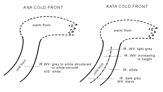
in the VIS image the cloud band mostly shows white grey shades, demonstrating high albedo; - in the IR image the grey shades can vary between white and grey, depending on the existing conceptional sub-model (for instance Ana Cold Front or Kata Cold Front) (see Meteorological physical background) as well as on the stage of development within a single conceptual model;
- as with the IR image, the grey shades in the WV image also can vary between white and grey, according to classical conceptual model ideas: in the case of an Ana Cold Front the cloud band should be characterized by high pixel values (white), but lower pixel values (grey) in the case of a Kata Cold Front;
- in reality this differentiation is not so strict:
- the typical Ana Cold Front cloudiness can have a structured but often also smoothed appearance;
- the typical Kata cold front shows, in the IR and WV images, a structured appearance for the cloud band, sometimes even representing a typical Split Front character (see Cold Front - Split Front ); at the rear part of the cloud band grey shades are darker accompanied by lower pixel values, which often continuously increase northward to the point of the Occlusion; the leading part of the cloud band varies in IR and WV grey shades from light grey to white (see Meteorological physical background);
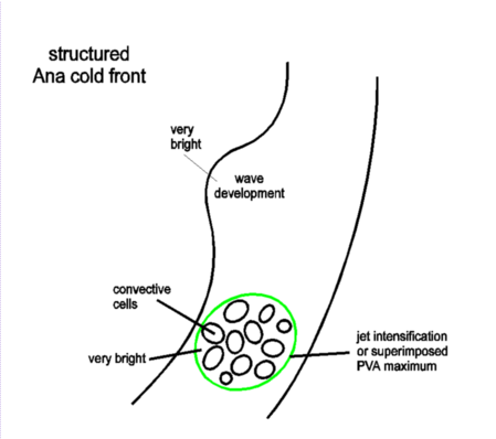
within the cloud band there can be subsynoptic areas forming a continuous substructure; mostly the IR image shows there a vertically and horizontally increased cloud area leading to brighter grey shades. Typical examples are Waves, Front Intensifications by Jet Crossing or merely situations with superimposed PVA maxima (see Key parameters, Wave and Front Intensification By Jet Crossing
|
|
|
|
|
17 April 1996/06.00 UTC - Meteosat IR enhanced image
|
17 April 1996/06.00 UTC - Meteosat IR image; SatRep overlay: names of conceptual models
|
|
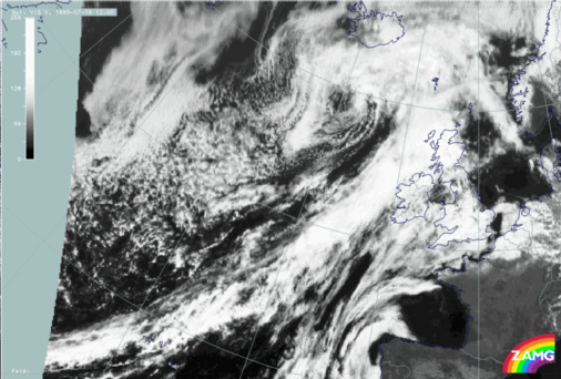
19 July 1995/12.00 UTC - Meteosat VIS image; Ana cold front
|
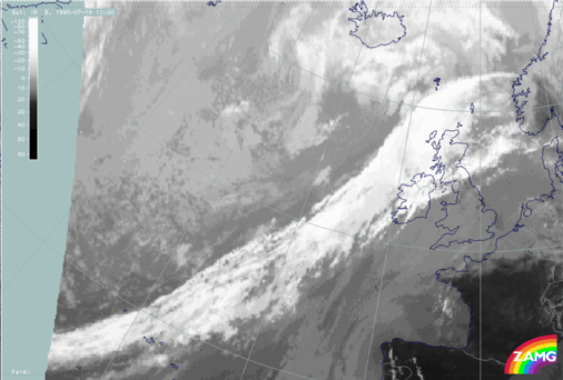
19 July 1995/12.00 UTC - Meteosat IR image; Ana cold front
|
|
|
|
|
|
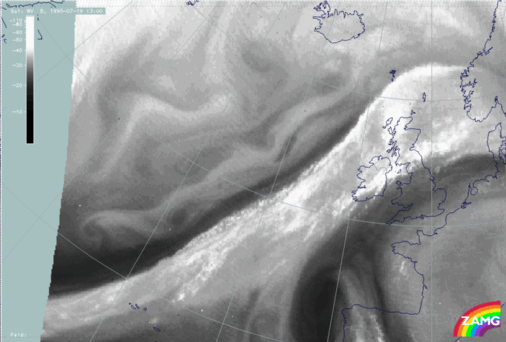
19 July 1995/13.00 UTC - Meteosat WV image; Ana cold front
|
The cloud band in the VIS image is characterized by brighter grey shades in the leading and middle part of the band, while the rear part is much more broken with transparent cloudiness (easy to recognize from approximately 40N/30W to approximately 50N/20W).
In the IR image this is quite opposite with bright grey shades denoting colder and therefore higher cloud tops from the middle to the rear part. This indicates multi-layered cloudiness with more and more higher cloud tops to the rearward edge and fits well with the classical ideas described in the meteorological physical background.
These higher cloud tops are even more recognizable in the WV image. The most characteristic features in this channel are the sharp rear cloud edge and the black stripe of dry air parallel to the cloud band (pronounced gradient from white to black).
|
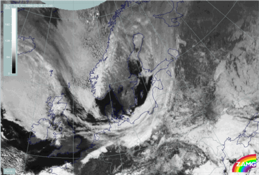
29 February 1996/12.00 UTC - Meteosat VIS image; Kata cold front
|
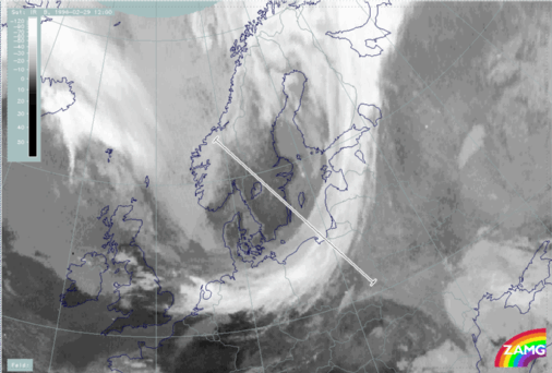
29 February 1996/12.00 UTC - Meteosat IR image; Kata cold front; position of vertical cross section indicated
|
|
|
|
|
|
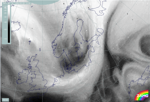
29 February 1996/12.00 UTC - Meteosat WV image; Kata cold front
|
The cloud band in the VIS image shows brighter grey shades in the rear part of the band, for instance from north Germany across the Baltic Sea to the south coast of Finland.
This is completely opposite to the IR and WV images where the lower grey shades, denoting warmer cloud tops, can be found. Dry air in the WV image overflows the rear part of the cloud band. Such a situation is in accordance with the classical ideas of the Kata Cold Front describing cloud dissolution by advection of dry sinking air (see Meteorological physical background). This is also opposite to the Ana Front model.

