COLD FRONT - KEY PARAMETERS
by ZAMG
- Equivalent thickness
Crowding zone of the equivalent thickness:- Ana Cold Front: within the cloud band
- Kata Cold Front: behind the cloud band
- Thermal front parameter (TFP)
Maximum of the TFP accompanies the cloud band:- Ana Cold Front: within the leading area of the cloud band
- Kata Cold Front: within the rear area of the cloud band
- Temperature advection (TA)
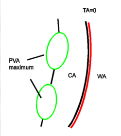
The field of TA shows (weak) WA in front of, and (pronounced) CA behind the surface front. Depending on the conceptual model the zero line of TA should be found within or very close to the cloud band:- Ana Cold Front: cloudiness usually within CA, TA=0 in front of cloud band
- Kata Cold Front: cloudiness usually within WA, TA=0 within the cloud band
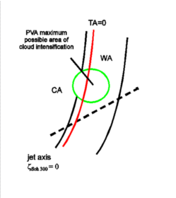
- Positive vorticity advection (PVA) in upper levels
PVA maxima can be found near the rear edge of the cloud band indicating the propagation of the upper level trough and/or the approach of a jet streak (see Front Intensification By Jet Crossing ). - Isotachs at 300 hPa
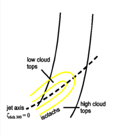
- Ana Cold Front: the jet is situated behind and parallel to the Cold Front cloudiness, the cloud band is on the anticyclonic side of the jet, the jet crosses the frontal system in the area of the point of the Occlusion
- Kata Cold Front: the jet crosses the surface cold front at a sharp angle; according to the crossing point the cloud band can be on the anticyclonic or cyclonic side of the jet
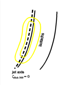
- Shear vorticity at 300 hPa
Zero line of the shear vorticity:- Ana Cold Front: the zero line is close to and parallel to the rear cloud edge
- Kata Cold Front: the zero line crosses the Cold Front, usually it accompanies the transition of the high cloud tops on the anticyclonic side from the lower cloud tops on the cyclonic side of the zero line; the latter are the result of cloud dissolution within dry air on the cyclonic side see Cloud structure in satellite image).
|
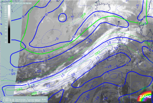
19 July 1995/06.00 UTC - Meteosat IR image; Ana cold front; blue: thermal front parameter (TFP) 500/850 hPa, green: equivalent thickness
500/850 hPa
|
|

|
|
|
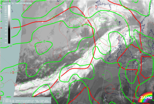
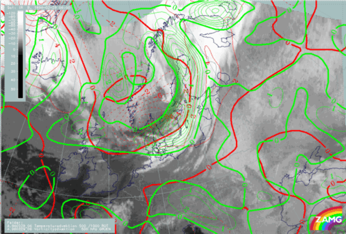
19 July 1995/06.00 UTC - Meteosat IR image; Ana cold front; red: temperature advection 500/1000 hPa, green: vorticity advection 500
hPa
|
|
|
|
|
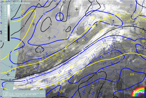
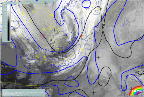
19 July 1995/06.00 UTC - Meteosat IR image; Ana cold front; blue: thermal front parameter (TFP) 500/850 hPa, yellow: isotachs 300 hPa,
black: zero line of shear vorticity 300 hPa
|
|
|
|
|
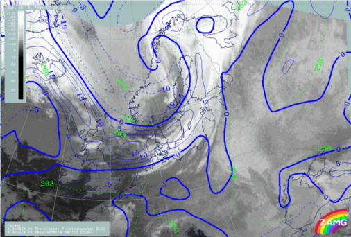
29 February 1996/06.00 UTC - Meteosat IR image; Kata cold front; blue: thermal front parameter (TFP) 500/850 hPa, green: equivalent
thickness 500/850 hPa
|
|

|
|
|
29 February 1996/06.00 UTC - Meteosat IR image; Kata cold front; red: temperature advection 500/1000 hPa, green: vorticity advection
500 hPa
|
|
|
|
|
29 February 1996/06.00 UTC - Meteosat IR image; Kata cold front; blue: thermal front parameter (TFP) 500/850 hPa, yellow: isotachs 300
hPa, black: zero line of shear vorticity 300 hPa
|
|
|
|


