![]()
The Real Time Archiving and Decoding of Dropsonde Data has been setup as part of CIRA’s Cal/Val and JPSS-PGRR projects. The dropsonde data are downloaded from the NHC website, and the decoded data with some additional preprocessed data are archived on a NAS drive, and are available for other projects as well. (J. Dostalek, G. Chirokova)
Verification of the ATMS soundings from Atlantic and east Pacific against dropsonde data: Using the existing dropsonde decoder (developed as part of Cal/Val project) the ATMS temperature and moisture soundings were compared with dropsondes as a function of distance from the storm center. That work is part of JPSS-PGRR project. For the collocation the ATMS sounding closest to the dropsonde was selected within one hour and 100 km from the dropsonde release time and location. The comparison of dropsondes with ATMS soundings shows that a) Close to the storm center (0-350 km) the ATMS performance is usually not very good, especially for moisture soundings b) Away from the storm center (more than 350 km) the ATMS usually performs better; however, the ATMS is lacking vertical resolution, so sometimes even relatively deep dry or moist layers are completely missing in the ATMS soundings. Also ATMS soundings do not perform very well close to the surface, being often too dry and too cold. c) Temperature soundings are usually better than moisture soundings. Figure 1 shows two examples of the dropsonde and ATMS collocation. The left panel shows a bad case, close to the storm center (216 km from the storm center), and the right panel shows a good case (401 km from the storm center). Both cases are from AL06 2014, Edouard. The results of the comparison will be used to correct ATMS soundings for systematic errors, which should provide better input to the Maximum Potential intensity (MPI) algorithm. (G. Chirokova)
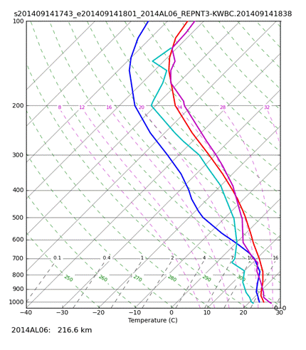
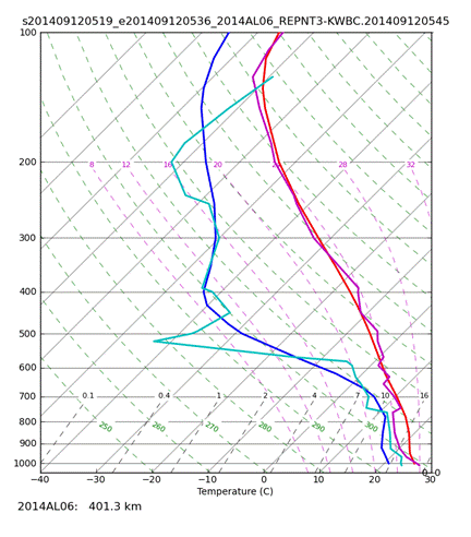
Figure 1. Example of the dropsonde and ATMS soundings collocation. The bad case (left) is for the sounding 216 km away from the storm center, and the good case (right) is 401 km from the storm center. Both examples are for the Hurricane Edouard, AL06 2014. The red and blue lines are T and Td profiles from ATMS, respectively, and the purple and teal lines are T and Td from the dropsondes.
Development of an automated eye-detection algorithm: As a part of JPSS-PGRR project, work has been performed to prepare previously collected dataset consisting of 2677 geostationary infrared images to be used to train a machine learning algorithm to perform automatic classification. Each image consists of an 80x80 pixel area centered on a tropical cyclone. In this state, each image can be thought of as a vector with 6400 values. Each of these vectors describes a point in a space described by 6400 dimensions. This data is too high dimensional relative to the number of available samples to expect to obtain good classifications from a machine learning algorithm. That is, the samples available do not explain a significant portion of the space represented by 6400 dimensions. To prepare the dataset, principle component analysis (PCA) was performed to find the underlying patterns contained in the data. Specifically, PCA was performed to find a set of eigenvectors that account for 90% of the variance of the data. After performing the analysis, it was found that 11 eigenvectors were needed for that purpose. The two most significant eigenvectors can be seen in Figure 1. The eigenvectors were then used for dimension reduction. Using a projection matrix generated from the eigenvectors, the data were projected from a 2677x6400 element matrix to a 2677x11 element matrix. At this point, the data is in a state where it can be used as a training set for a machine learning algorithm to perform automated eye-detection. (R. DeMaria)
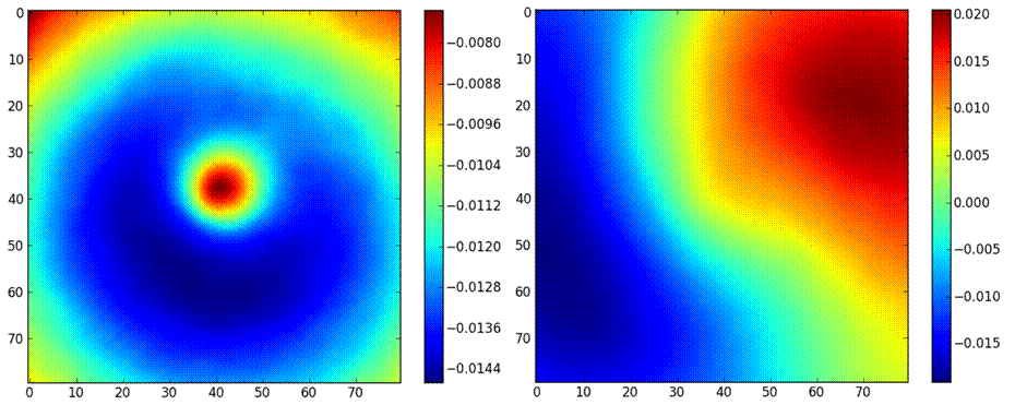
Figure 1. The First (left) and second (right) most significant of the 11 eigenvectors that explain 90% of the variance in the IR dataset.
NOAA/NESDIS/PSDI/NDE/S-NPP Tropical Cyclone Algorithm: Three upgrades (NPP_TC v1.4.1-4) were developed, tested and migrated to the NDE development and test servers. Upgrades included minor bug fixes. ATMS data became available in real-time end of August 2014 and CIRA real-time 2 hourly test runs began 1 September 2014. NPP_TC v1.5.0 which includes ATMS quality control checks, along with minor updates is currently being tested and will be migrated to NDE testing in October. (S. Longmore, A. Schumacher, J. Dostalek)
NOAA/NESDIS/PSDI/AMSU Tropical Cyclone Algorithm: AMSU_TC v1.2.0 is currently being developed which will included AMSU quality control checking as well as several features already integrated into NPP_TC v1.5.0 (driver updates, scaling/offset/threshold checking in algorithm, etc. (S. Longmore, J. Dostalek)
Wind speed probability upgrades: Several updates have been made to the Monte Carlo wind speed probability algorithm under support from the Joint Hurricane Testbed. The time interpolation scheme was updated from a linear interpolation to a spline fit, which produces a more realistic official track from which the wind speed probabilities are calculated. In addition, extratropical cases were removed from the experimental dataset so the product-derived error statistics match those of the official National Hurricane Center verification report for the last 5 years. This update will allow for consistency between NHC’s various uncertainty products. Finally, a time-integrated estimate of forecast uncertainty based on Goerss Predicted Consensus Error has been developed and is currently being refined based on feedback from NHC points of contact. These updates have been incorporated into an experimental version of the MC model that is currently running at CIRA (http://rammb.cira.colostate.edu/research/tropical_cyclones/mc_model/). (A. Schumacher)
S-NPP MiRS ATMS-based tropical cyclone products: The S-NPP MiRS ATMS-based tropical cyclone products algorithm is currently running in real-time at CIRA. CIRA scientists recently gained real-time access to 30-second MiRS ATMS granule via NDE Distribution, which allowed real-time runs to be established late last month. Real time testing will continue for the next few weeks to allow developers to finalize the algorithm for real-time operations. A final algorithm will be delivered around the end of September, and the operational readiness review and briefing to the SPSRB is expected to occur in October. (A. Schumacher, S. Longmore, J. Dostalek, J. Knaff)
Seasonal updates to the Monte Carlo Wind Speed Probability product: Seasonal updates to the MC Model were completed in July, upon the receipt of the final 2013 N.W. Pacific b-decks from the Joint Typhoon Warning Center. The updated algorithm and error statistic files were delivered to C. Sampson at the Naval Research Lab and M. DeMaria and the National Hurricane Center. (A. Schumacher)
PSDI and Cal/Val projects operational tropical cyclone products updated: Work continued on the PSDI and Cal/Val projects to replace the old, statistical retrieval algorithm used to create operational tropical cyclone products with the new MIRS retrievals from both the AMSU instrument and the ATMS instrument. The activities included a teleconference with the MIRS development team, code revisions, and interaction with NDE and OSPO. (J. Dostalek)
2014 HFIP Demonstration: The National Hurricane Center has selected SPICE as one of the HFIP Stream 1.5 models it will use during the 2014 demonstration period (1 Aug – 31 Oct 2014) for tropical cyclone intensity guidance. (K. Musgrave)
Proposals to NWS: Two proposals were submitted for consideration to “Round 1 of Research to Operation Initiative.” The first (S. Fletcher, PI) addresses the potential for assimilating IR wind proxy data in the HWRF model as an alternative to ad hoc vortex initialization methods currently used and the more difficult task of assimilating radiances in cloudy/rainy scenes. The second (K. Musgrave, PI) proposes to expand the Statistical Prediction of Intensity from a Consensus Ensemble (SPICE), currently using on GFS-based, official LGEM/SHIPS and LGEM/SHIPS run on regional models (HWRF and GFDL), to use the suite of available global models. (J. Knaff, K. Musgrave, S. Fletcher)
![]()