xxxx
Severe Storms (Weaver, Dostalek, Grasso, Bikos, Coleman)
Reviewer comments for the manuscript Noteworthy Aspects of a Severe Left Moving Thunderstorm of 25 May 1999" by J. Dostalek, J. Weaver and L. Phillips (NWS/LBB) have been addressed and the paper was returned to the editor at Weather and Forecasting. The paper had been accepted with minor comments.
A Picture of the Month submission for Mon. Wea. Rev. entitled Some Frequently overlooked Visual Severe Thunderstorm Characteristics observed on GOES Imagery a Topic for Future Research by J.F. Weaver and D. Lindsey is in preparation. The following two figures show some slides from a VISIT teletraining session that includes this topic.
Click on images to enlarge.
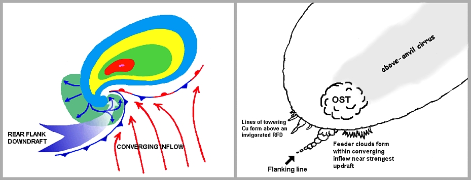
Figure 1. a) Schematic of idealized PPI radar reflectivity from a supercell thunderstorm, along with some storm scale features often referenced in the literature, and b) schematic of a few cloud features that frequently appear on visible satellite imagery in association with supercell storms.
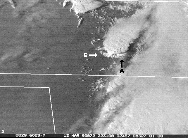
Figure 2. Example of visible satellite image from 13 Mar 1990 taken at 22:31 UTC. A storm near Hesston, KS transitions from a severe to tornadic thunderstorm. Arrow A points to compact inflow feeder clouds associated with the storms intense inflow, arrow B points to lines of towering cumulus forming above a newly-formed rear flank downdraft.
The new VISIT teletraining session entitled, Use of GOES/RSO Imagery
with Other Remote Sensor Data for Diagnosing Severe Weather across the
CONUS is now being taught as a two-part session. Each segment is
1 1/2 hours long. The new session features several severe thunderstorm
cases studies from various regions around the country, and focuses on the
use of RSO imagery to diagnose the near-storm environment. Satellite
data for the study are from the archived RSO data set at CIRA.