Severe
Storms
Weaver, Dostalek, Grasso, Bikos,
Motta
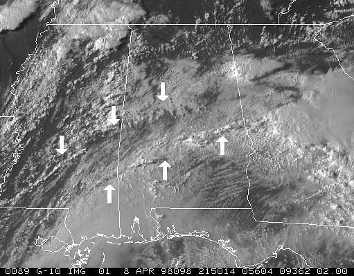
GOES-10 assessment data from the 08 Apr 98, Birmingham,
Alabama tornado case is proving to be an excellent data set for helping
to understand the environment preceding southeastern U.S. tornadoes.
In particular, the low-level broken-to-overcast sky coverage that we thought
might mask important low-level boundaries, may actually reveal previously
undefined features associated with the evolution of the boundary layer.
In the case of 08 Apr 98, for example, we find two cloud lines which seem
to mark fairly large-scale convergence zones. The origin(s) of these
convergence zones, and their role(s) in the convective cycle, is
not yet fully understood. Research continues.
 |
|
GOES-10 visible image from 2150 UTC on 08Apr98 showing
two of the convergence lines that appeared to play important roles in the
development of severe convection. The southernmost line formed along
a cloudy versus clear boundary. (Click on image to enlarge) |
|
|
Reviewer's comments have been received from National Weather
Digest for the 31 May 1996 Kansas and Colorado severe weather case study.
The results were favorable, both reviewers having accepted the manuscript
with minor revisions. Questions/concerns will be addressed
and the article sent back for publication. An electronic version
of portions of this case (called "Detecting low-level thunderstorm Outflow
boundaries using GOES at night") can be viewed at -- http://www.cira.colostate.edu/ramm/visit/lto.html
GOES-8 SRSO imagery and WSR-88D data from 17 May 1996
have been synthesized and show that the development of a long-lived left
moving storm was triggered by an expanding low-level thunderstorm outflow
boundary interacting with a pre-existing convergence line. Historical
numerical modeling evidence suggests that left moving updrafts develop
from the "classic" storm splitting process. This study hopes to show that,
at times, left movers might develop by another process. A "note" to Weather
and Forecasting is being prepared.
Back to the top
Return to the RAMM-CIRA Quarterly Report
home page