DeMaria, Dostalek, Motta, Molenar, Weaver, Bikos, Zajac
Tallahassee Summer Sea Breeze Climatology project:
Data collection and archival focusing on the GOES-8 1 km visible
imagery and 4 km 3.9 um and 10.7 um imagery was initiated on June 1 and
will continue through August 31. This is part of a collaborative
project between Ken Gould, NWS Tallahassee, Florida, and CIRA and was initiated
in 1995. The project has been tailored to stratify the satellite
imagery by boundary layer wind regimes that essentially show the effects
of wind speed and direction on the strength of convective development along
the sea breeze fronts. In the past the imagery has been averaged
and the results qualitative. This year we are converting the analysis
to look at cloud frequencies and take a quantitative approach. Before
we can run the analysis, image navigation checks for August have to be
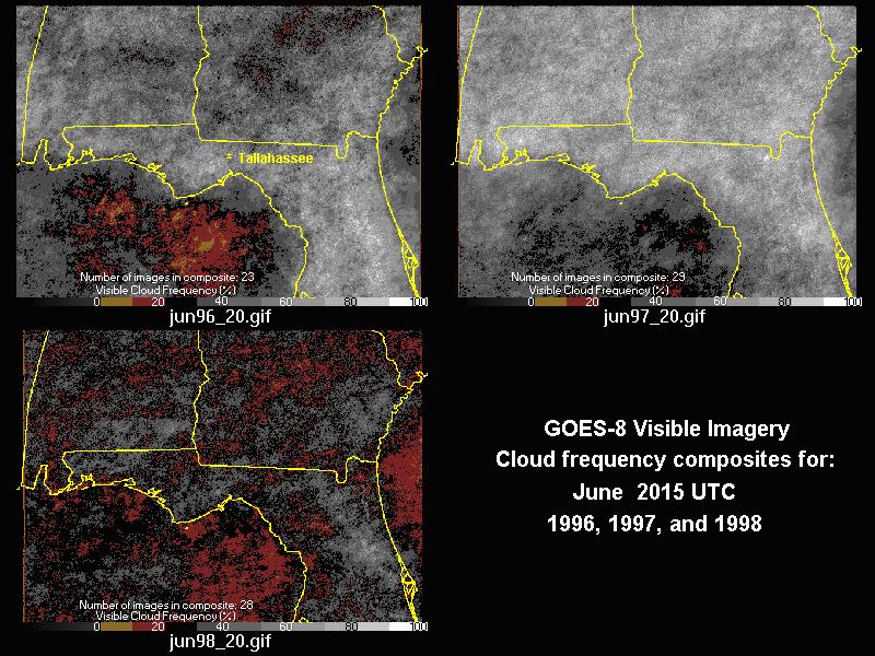
finished. The following image (tae_jun.gif) gives a quick look at
some of the monthly variability that will show up in the seasonal regime
designations.
|
|
Tae_jun.gif: A 3-panel image depicting cloud frequency derived from visible imagery at 20:15 UTC for June of 1996, 1997 and 1998. Recall that in 1998, Florida was experiencing unusually dry conditions and many fires broke out across the state. (Click on image to enlarge) |
M. DeMaria continues his interaction with the National Hurricane Center (NHC) on the development of a Statistical Hurricane Intensity Prediction Scheme (SHIPS). The version of SHIPS that is run operationally by the NHC requires a forecast track. However, the barotropic track model currently used for this input has a northward bias for high latitude tropical cyclones. To make the SHIPS forecasts more reliable, the barotropic model forecast track was replaced with the official forecast track. The change was implemented just prior to Hurricane Adrian in the East Pacific. Methods are being developed to further improve this model by including GOES channel 4 imagery in the prediction. During the 1999 hurricane season so far, SHIPS has shown intensity forecast skill for the two storms which occurred as of June 1999 in the NHC area of responsibility. (Tropical storm Arlene in the Atlantic and Hurricane Adrian in the Eastern North Pacific).
RAMM team participated in a teleconference led by the NWS Office of Meteorology (OM) satellite program to address concerns that Rapid Scan Operations (RSO) initiated by the NWS were not being scheduled as requested. The entire process was examined and solutions were discussed. One idea proposed by OM was to have an "auto-trigger" for RSO. The proposed trigger is the Storm Prediction Center issuance of a moderate risk (or greater) of severe weather. Upcoming GOES assessment activities were also discussed.
J. Weaver, B. Zajac, and D. Bikos visited NWS forecast offices in Denver, Colorado and Cheyenne, Wyoming to discuss a cooperative severe storm research project being conducted in northeast Colorado this spring and summer. The goal of the project is to collect and study data sets from 2-3 severe thunderstorms. Topics of interest include the prestorm environment and cloud-top signatures of severe storms. Remote sensor data will include GOES RSO imagery, GOES sounder data, and observations from WSR-88D radars in Denver and Cheyenne and Colorado State University's CHILL and Pawnee Doppler radars (CHILL has dual-polarization capability).
Daily weather discussion calls to the Lubbock NWSFO were made to coordinate RSO calls for the joint dryline experiment.