![]()
Improving tropical cyclone surface wind estimates: A new and improved method to estimate the tropical cyclone near-surface winds using globally and routinely available tropical cyclone (TC) information and infrared (IR) satellite imagery has been developed. Product development makes use of aircraft reconnaissance (1995-2012) that has been analyzed to a 1 km by 10o polar grid that extends outward 165 km from the TC center. These analyses are then rotated to a direction-relative framework, normalized by dividing the wind field divided by the observed maximum and decomposed into azimuthal wavenumbers in terms of amplitudes and phases. Using a single field principle component method the amplitudes and phases of the wind field are then statistically related to principle components of motion-relative IR images and factors related to the climatological radius of maximum winds. The resulting wind field reconstruction, mean absolute errors (MAE) shown in the figure below, significantly improves on methods currently used for NESDIS multi-platform tropical cyclone surface wind analysis (MTCSWA). The work was submitted to the Journal of Applied Meteorology and Climatology. (J. Knaff, D. Molenar, S. Longmore, R. DeMaria)
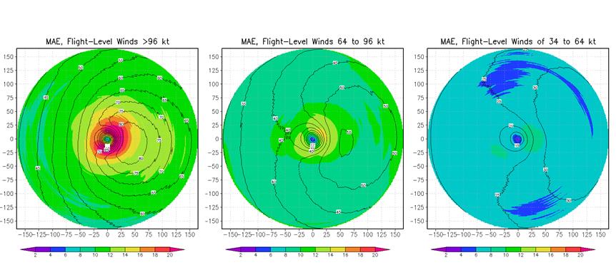
Figure: Dependent mean wind field (contours) and absolute errors (MAE, shaded) stratified by flight-level analysis winds with cases with winds greater than 95 kt (left), winds 64 to 95 kt (middle) and winds 34 to 64 kt (right). Note the largest errors are inside the radius of maximum wind where the gradients in wind speed are the largest. The scale is the same for all figure panels.
Objective tropical cyclone wind radii from IR-based size metric: A method has been developed to estimated tropical cyclone (TC) significant wind radii (i.e., winds exceeding 34, 50, and 64 kt) from the storm translation vector, the maximum sustained winds, and the IR-based TC size metric. An example of the output of this method is shown in the figure below for Hurricane Ivan. The method verifies well with observations with errors that are similar to the best objective methods. This is a significant step toward statistical TC wind radii prediction since historical records of the IR TC size metric (see Knaff et al. 2014, J. Climate) exist for the last 20+ years; providing a consistent measure of TC size. Work has begun on the next phase of this project with the ultimate goal of statistical wind radii guidance within the SHIPS model framework. (J. Knaff)
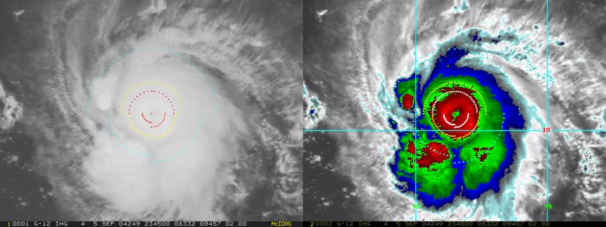
Figure: IR and enhanced IR image of Hurricane Ivan 5 September 2004 at 2345 UTC showing objectively estimated wind radii. 34-kt wind radii are show in cyan, 50-kt wind radii are shown in yellow and 64-kt wind radii are shown in red (left), white (right). Ivan had a maximum sustained wind of 115 kt and its motion was 315 at 5 kt.
Tropical cyclone eye detection in IR images: Using existing historical operational tropical cyclone intensity fixes (i.e., Dvorak) a method has been developed to objectively indicate whether or not an eye exists in the geostationary image from the information contained in the fix. To examine how well this method works, we examined the time periods of first eye identification to test the veracity of the method. Findings suggest that a combination of this method and a rather low intensity threshold (~55- 60 kt) may provide a relatively easy method to identify periods when eye features exist in IR and visible imagery. A few examples of first eye cases from the Atlantic, East Pacific, West Pacific and Southern Hemisphere are shown below. In the next quarter this data set will be utilized for a number of tropical cyclone projects. (J. Knaff, R. DeMaria)
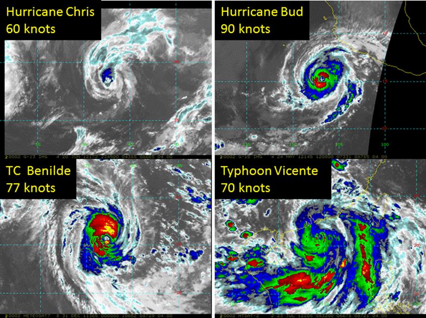
Figure: Objectively identified first tropical cyclone eye images from 2012. Shown are Tropical Storm Chris, Hurricane Bud, Tropical Cyclone Benlidle, and Typhoon Vicente in the North Atlantic, East Pacific, South Indian, and western North Pacific basins, respectively. Intensity information is provided for each panel.
![]()