![]()
Suomi NPP VIIRS Latency Statistics: One of the larger issues with the real-time use of Suomi NPP VIIRS non-direct-broadcast (non-DB) Imagery is the long latency between image times and image availability. Efforts are being pursued to reduce the latency of non-DB global imagery. In order to monitor any potential reductions in latency, the VIIRS Imagery collection at RAMMB/CIRA is now accompanied by statistics that measure both the delay in creation of imagery granules (time difference between image time and granule creation) as well as the delay in the acquisition of those granules (time difference between granule creation and granule acquisition). The first latency number is usually much larger, often on the order of 6 hours, and is a function of the servers (GRAVITE/CLASS and Atmos PEATE). The second part of the latency is much smaller, on the order of less than an hour, and is a function of the transfer of the granules from the servers to the RAMMB/CIRA rotating archive. The total latency is often more than 7 hours for all but the M-band EDRs which already have lower latency (usually on the order of 2 hours)! A reduction in the longer latency of the I-band EDRs and DNB/NCC imagery, to match that of the M-band EDRs, is the goal of these efforts. (D. Hillger, S. Finley)
Using Suomi NPP VIIRS to Look for Traces of MH370: The disappearance of Malaysian flight 370 has captured a lot of attention not only in the news media but in the remote sensing community, in trying to see if any traces of the plane or its wreckage might be found. Although the resolution of weather satellite imagery is way too coarse to see the airplane, there is still the possibility of detecting either a thermal signal in infrared imagery or a visible signal in the VIIRS day-night-band (DNB) imagery. Thanks to imagery experts Steve Miller, William Straka, and Curtis Seaman, the VIIRS archive has been scanned for strange signals in the large coverage area that the airplane is thought to have been flying. The only signal found was a bright streak in the Andaman Sea just to the west of Thailand on 7 March 2014 at ~1850 UTC (8 March ~2:50 AM local Malaysian time) which appears to reside above the cirrus present in the area. Location is 7.22°N, 96.27°E, approximately 500 km from last contact at 1:30 AM local time. It is theoretically possible for a commercial aircraft to have flown that ~500 km distance 1 h 20 min. However, there is no correlative thermal signature (in VIIRS 3.74 μm imagery) associated with the streak. Therefore, the feature is likely just a meteor, examples of which have been seen numerous times in DNB nighttime imagery. (S. Miller, C. Seaman, D. Hillger)
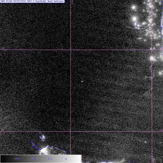
Figure 1a: Day-Night-Band image of what is thought to be a meteor as seen by Suomi NPP VIIRS on 7 March 2014 at ~1850 UTC off the west coast of Thailand.

Figure 1b: Blowup of the likely meteor signal from Figure 1a.
VIIRS Imagery EDR User’s Guide: A draft version of the VIIRS Imagery EDR User’s Guide has been posted to the STAR-JPSS website, and is available for review and feedback. The VIIRS Imagery User’s Guide was written to provide valuable background information to users of VIIRS Imagery data. This document also fulfills a JPSS program requirement as a component of VIIRS Imagery EDRs being upgraded to “Validation Stage 3.” This User’s Guide discusses differences between SDR and EDR imagery, the relationship between the Day/Night Band and Near Constant Contrast imagery, and other information specific to acquiring, processing and displaying VIIRS imagery products. This document will become a NOAA Technical Report following a review of the document and clarification of the procedures for submission of technical reports. The draft document is available at: http://www.star.nesdis.noaa.gov/JPSS/ATBD.php (listed under User Guides). An image of the cover is shown below. (C. Seaman, D. Hillger)
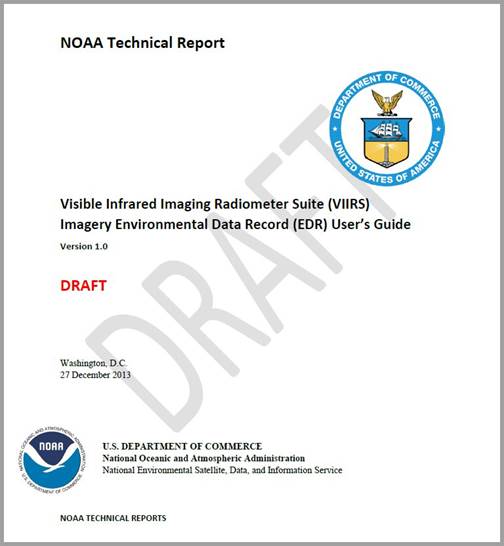
Figure: Cover of the VIIRS Imagery EDR User’s Guide, which has been submitted to be a NOAA Technical Report.
JPSS Annual Meeting: D. Hillger (NOAA) and C. Seaman (CIRA) participated in the first JPSS Annual Meeting, held 12-16 May 2014 at the NCWCP in College Park MD. Hillger gave 2 talks as co-lead of the VIIRS EDR Imagery Team: the first talk being a summary of the Imagery Team’s work to date; and the second talk was a summary of things learned at the meeting, in particular potential future interactions between the SST and Cryo Teams as users of EDR Imagery. There was also a combined breakout session on Imagery and Clouds that was well attended by users as well as Team members, some via teleconference. The live report on that session was given by Bill Ward from NWS Hawaii. Other interactions during this trip included Hillger meeting with Lori Brown to help resolve issues with NOAA Technical Reports (TRs), which are currently stalled due to there being no single source for reviewing, numbering, and processing of these types of reports since the death of Susan Devine. At least 2 of the StAR JPSS Teams (VIIRS SDR and EDR Imagery) have their product User’s Guides in NOAA TR form, but are as yet not completed. Hillger also met with Mark Ruminski at SAB about the use of VIIRS Imagery in some of SAB’s hazards products, as well as met with Sean Helfrich of the National Ice Center about their use of EDR Imagery and how the Team might help them. Additional meetings included regularly-scheduled weekly CoRP and JPSS meetings that were attended in person rather than on the telephone. Seaman gave 2 talks as well, one on EDR Imagery and the other on the EDR Cloud Base Height (CBH) algorithm for the Cloud Team. Finally, Hillger also attended the NOAA Awards ceremony on 20 May 2014, as one of 13 recipients named on a Bronze Medal presented to the leaders of the StAR JPSS EDR Teams. (D. Hillger, C. Seaman)
Terrain-Corrected Geolocations for VIIRS DNB Now Available: Terrain corrected (TC) geolocations for the VIIRS Day-Night-Band (DNB) are now being supplied as of 22 May 2014 at ~1440 UTC. (These TC geolocations are in addition to the ellipsoid geolocations that have always been provided for DNB. Both TC and ellipsoid geolocations have always been available for the I-band and M-band SDRs.) An increase in the DNB geolocation file size from IDPS was immediately noticed. (Apparently the change for Direct Broadcast users did not take place at the same time, but will occur when the code is updated.) Three separate analyses/presentations comparing the effect of the new terrain-corrected vs. non terrain-corrected geolocations are available at http://rammb.cira.colostate.edu/projects/npp/#events. The analyses were put together by C. Seaman, W. Straka, III, and S. Miller. (D. Hillger)
NOAA Technical Report Restart: D. Hillger is helping Lori Brown revise the NOAA Technical Report (TR) creation process, which was left in a state of confusion after the death of Susan Devine in 2012. Lori and Don have taken charge of revising/updating the NOAA TR process, to resolve current issues with TRs and restart the issuance of TR numbers once again. Currently there are a few TRs that have conflicting/duplicate numbering because the process has not been overseen by one person. The goal is to standardize the review and numbering of TRs and to then hopefully have the system taken over by someone at NESDIS with the involvement of the NOAA Libraries. Lori has made a list of all existing TRs, and is working on resolving the conflicting numbering issues, while Don is helping revise a TR Guidance document and the necessary forms and templates needed. The reason this is important, in that at least 2 STAR JPSS Teams have VIIRS Users Guides that would best be made into NOAA Technical Reports. The Users Guides are part of the Suomi NPP Validation requirements, and formalizing these documents gets them permanently into the NOAA Library system. (D. Hillger)
VIIRS Online Imagery Labeling Fixed: After years of displaying random VIIRS imagery granules for quality checking, an error in the labeling of the images has been fixed. Label details are provided on the granule images, indicating the center latitude and longitude, the ascending or descending node of the orbit, and now the solar zenith angle and day/night indicator. Previously the day/night indicator was sometimes faulty because the solar zenith angle had been computed with incorrect input information, including the confusion between positive and negative longitude systems. The day/night flag error has been tracked down and fixed. The VIIRS online imagery is available at http://rammb.cira.colostate.edu/ramsdis/online/npp_viirs.asp. (D. Hillger)
![]()