| RAMMB CIRA 2nd Quarter Report |
|---|
January February March 2008
|
In a multi-agency effort investigating the use of satellites to provide wind information over the Polar regions, the RAMMB contribution is to use temperature profiles derived from AMSU-A radiances, along with the assumption of hydrostatic and dynamic balance (geostrophic, linear, and nonlinear), to estimate the wind field. Figures 1 and 2 show the wind speed bias and vector root mean square error (with respect to collocated radiosondes) as a function of pressure for a winter and a summer dataset, respectively. For the entire depth of the atmosphere the three balances had biases between -0.7 and -1.0 m s-1 and root mean square errors between 6 and 7 m s-1. In an attempt to improve the accuracy of these wind retrievals, the addition of an estimate of the irrotational wind will be implemented. Code is being developed which will solve the linear balance omega equation. Once omega is calculated, the velocity potential χ can be computed from ![]() . From there the irrotational component of the wind is found from
. From there the irrotational component of the wind is found from ![]() .
.
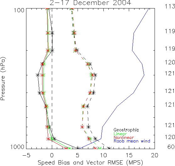
Figure 1. Wind speed bias and vector RMSE between the winds derived using the AMSU radiances and collocated radiosondes for the winter 2004 dataset. Solid lines are the bias and dashed lines are the RMSE, with the exception of the solid blue line, which is the mean radisonde-derived wind speed. The colors correspond to the different balance approximations. The number of comparisons at each level is given on the right hand side of the figure.
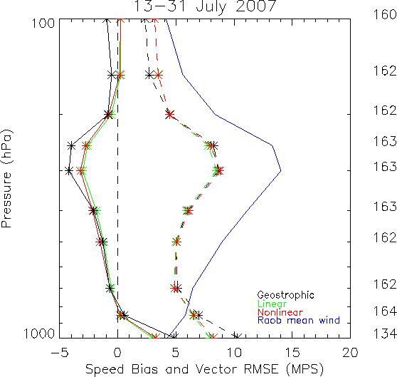
Figure. 2. Same as Figure 1, but for the summer 2007 dataset.
Henry’s Rule states that a stationary trough over the southwestern U.S. will begin to lift out when an upstream shortwave travels to 2200 km from the stationary trough. Nine cases are currently being analyzed, not only to assess the usefulness of the water vapor imagery in tracking the position of the upstream shortwave relative to the stationary low, but also to see if the behavior of the stationary low itself, as seen in satellite imagery, gives any indication that it will begin to lift out. Additional cases are being collected as well. An example of Henry’s rule is shown in Figure 3.
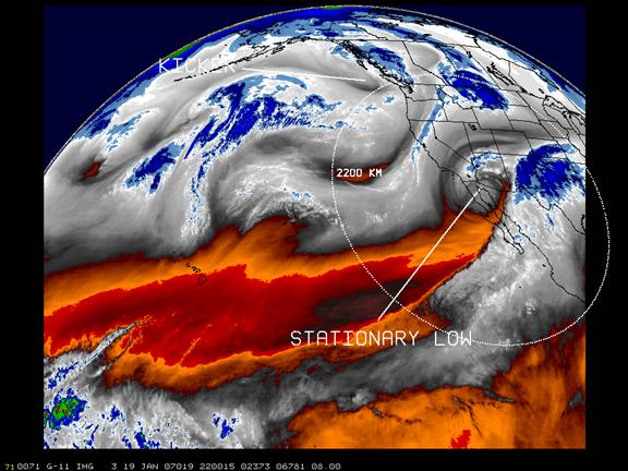
Figure 3. An example of Henry’s rule. Water vapor image from 2200 UTC 19 January 2007 just before the stationary low began to lift out. The locations of the stationary low, the “kicker” and the 2200 km radius from the stationary low are depicted.
As part of the project to develop a quantitative measure of the central surface pressure of midlatitude cyclones over the eastern Pacific Ocean from satellite imagery, the collection of GOES 10.7 μm infrared and 6.7 μm water vapor imagery has been completed for the winter season 2006-2007 and analysis begun. Imagery from the winter season 2007-2008 is currently being collected. (J. Dostalek)
The relationship between cloud morphology as seen in GOES 10.7 μm imagery and snowfall patterns over the central United States is being investigated. So far three cases have been selected, the data for them obtained, and analysis begun. Additional cases will also be added to the study. An issue arose concerning problems with reading the North American Regional Reanalysis (NARR) files in McIDAS. The McIDAS Users’ Group was contacted and a solution was suggested and will be implemented next quarter. The mean sea level pressure from the NARR data is used to track the surface low center of the systems. (J. Dostalek)
A proposal entitled “Investigation of the Mechanisms for Heavy Precipitation/Flooding from Landfalling Extratropical Cyclones Using Satellite Observations and Atmospheric Models” was submitted to NASA. The proposed research seeks to understand processes that control the intensification of Pacific extratropical cyclones and the generation of heavy precipitation when they move onto the west coast of the U.S. The principal investigator is Dr. Chungu Lu of CIRA/Boulder, and the project will be a joint effort between CIRA/Boulder and CIRA/Ft. Collins, as well as NOAA’s Earth System Research Laboratory. (J. Dostalek)
Processing of the large sector U.S. climatologies continues. Products completed include monthly large sector composites for November and December 2007. (Combs)
Processing of wind regime products continues. Monthly wind regime composites from both channel 1 and channel 4 for November and December 2007 have been completed. Combined monthly products have also been completed for November and December 2007. (Combs)
Preprocessing of GOES west data over the Eureka area continues. A new hourly has been hired and is presently being trained to take over this task. Processing and quality control for hours not normally processed but in our DVD archive have been completed for Jul-Sep 2005, May 2006, and May-Sept 2007. Next quarter we will start working on data pulled from the CIRA main archive. (Combs)
A meeting was held with Becca Mazur, an intern from the Eureka, CA National Weather Service office, on February 5, 2008 at CIRA. We made updates on the progress each group is making towards the marine stratus climatologies for the Eureka area. We discussed ways of determining marine stratus depth, data formats, and other ideas. (Combs)
Work to incorporate the wind regime cloud climatologies into the Cheyenne’s National Weather Service (NWS) office forecast is progressing. The procedure to convert the cloud composites into netCDF has met with some success. Currently, Deb Molenar is working to add navigation information into the netCDF format. (Combs)
MSG data available from the CIRA archive and FORTRAN programs from Stan Kidder to be used to read the MSG data were obtained. (Combs)
A study continues which involves using GOES-11 bands 4 and 5 to assist in retrieving boundary layer moisture depth. In addition to GOES and raob data, model data from the RUC and NAM were collected to provide supplementary information. Preliminary results show that the RUC consistently outperforms the NAM in short-term low-level moisture forecasts, and work is still ongoing to determine what value the GOES bands 4 and 5 data might provide. Finally, an inquiry was made about CIMSS' Li/Li moisture retrieval in hopes that the best possible moisture retrieval may be developed. (D. Lindsey)
The GOES Mesoscale Convective System (MCS) Index was successfully updated to work with grib2 data. As of the beginning of February 2008, NCEP model data switched from grib1 to grib2 format, so all algorithms making use of the model output needed to be updated. A new FY08 PSDI project involves transferring this product to NESDIS operations, so this update for grib2 data was timely and necessary. (D. Lindsey)
A poster was presented at the 3rd Conference on the Meteorological Applications of Lightning Data at the 2008 AMS Annual Meeting entitled "Examining a Possible Relationship Between Positive Dominated Storms and Cloud-Top Ice Crystal Size." Valuable discussions with a number of lightning researchers were held. (D. Lindsey)
![]()