Tropical Cyclone Research Current Product Development
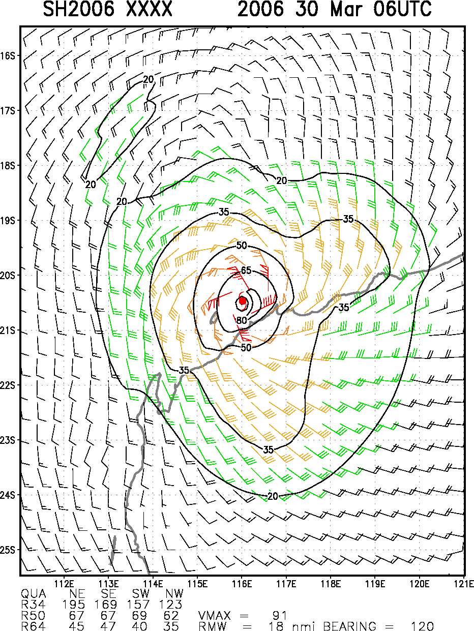
Work continues on a satellite only tropical cyclone surface wind analysis. This work combines in a specially developed analysis (cylindrical, variational) observations from feature tracked winds, SSMI winds, Quickscat winds, AMSU-derived 2-d wind fields, and IR-derived winds. The key ingredient is the recent development of an IR-based method to predict the winds associated with the core of the tropical cyclone. The combined analyses are run in real-time while the analysis method is improved. The current version uses a standard flight-level to surface wind correction over water, and decreases (turns) these winds an additional 20% (20 degrees) over land. An example of wind analyses from Tropical Cyclone Glenda (SH202006) just before landfall with an estimated intensity of 105 kt (03/30/06 at 06 UTC) is shown in Figure 1. Results of this scheme were presented at the AMS satellite conference in January. (J. Knaff)
Figure 1a
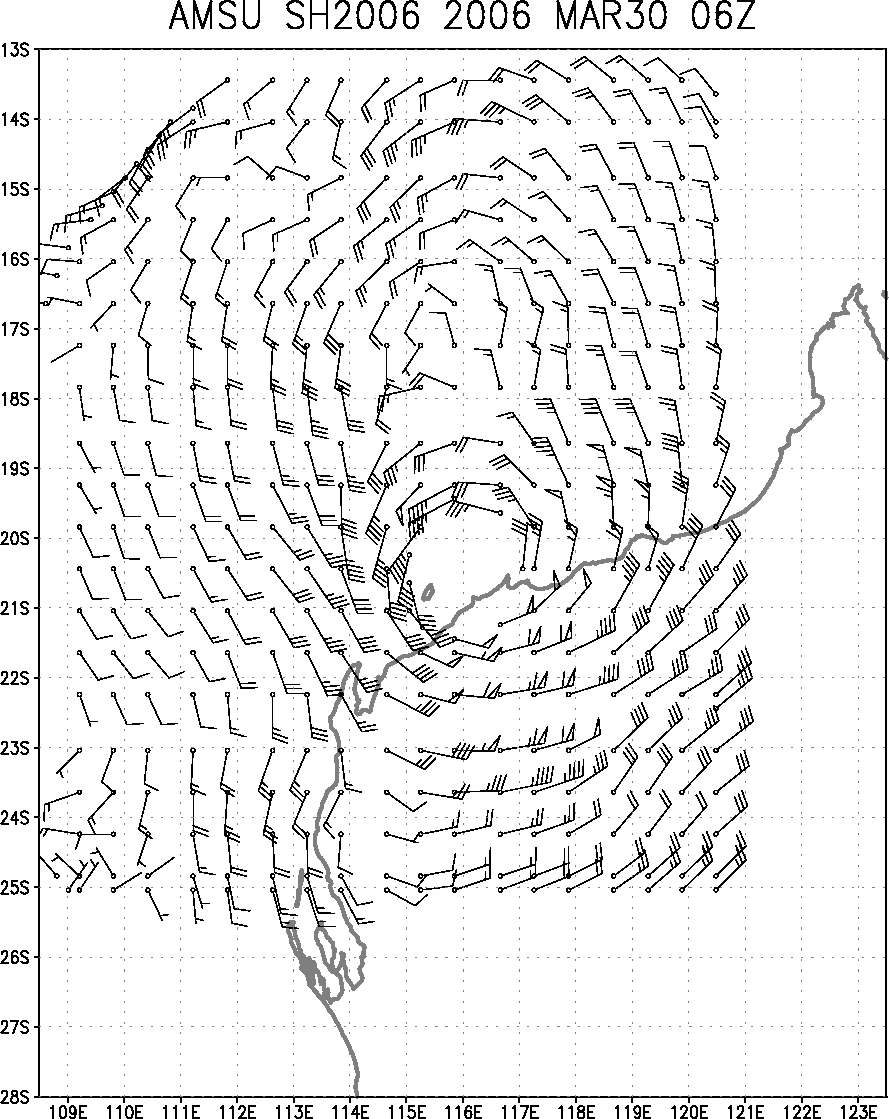
Figure 1b
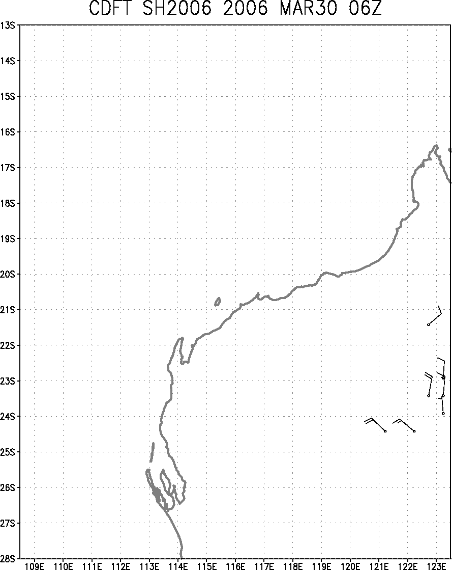
Figure 1c
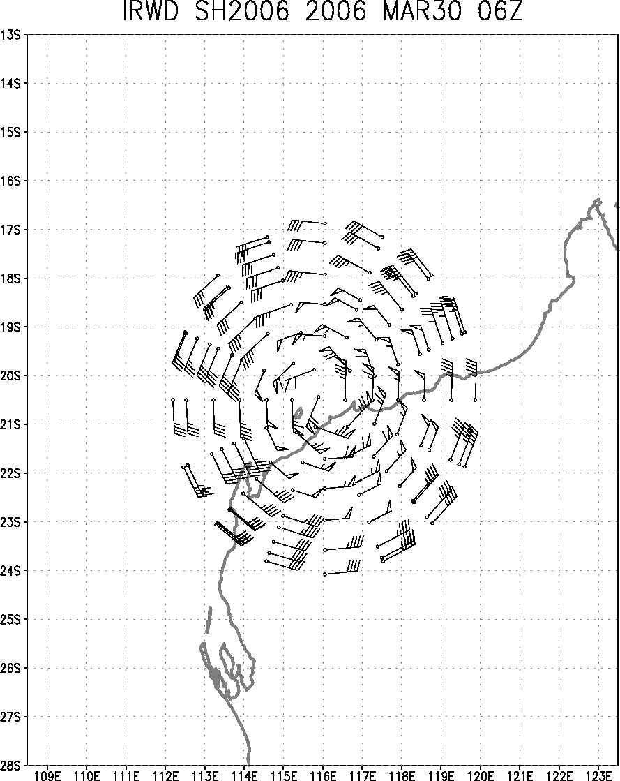
Figure 1d
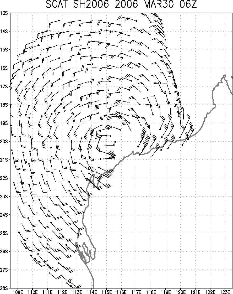
Figure 1e
Figure 1: Satellite-only surface wind analysis and associated input data (AMSU 2-d non-linear balance winds, cloud/feature tracked winds, IR-derived winds, and QuikScat) for the case of Tropical Cyclone Glenda near the time of landfall in Western Australia on March 30, 2006 at 0600UTC. Wind radii are given at the bottom of the figure.
The pressure vs. wind relationships of tropical cyclones have been re-evaluated using the last 15 years of tropical cyclone best track wind estimates and aircraft MSLP values to assess the relative importance of latitude, environmental pressure and tropical cyclone size. Both environmental pressure and tropical cyclone size are determined from numerical analyses and appear to have no dependency on the analysis used (NOGAPS, GFS, NCEP-Reanalysis). Findings suggest that all of these factors can be used to reduce the scatter in the current pressure wind relationships. Larger and higher latitude storms produce lower MSLP for the same maximum wind speed. Environmental pressure is additive, or in other words storms occurring in a higher pressure environment have higher MSLP. Relationships were developed to estimated the wind from quality pressure observations and to estimate the pressure given a good estimate of the maximum 10-m, 1-minute sustained wind. These relationships can be utilized in operational tropical cyclone centers throughout the world and for reanalysis of past tropical cyclone events. Maximum surface winds speeds estimated from aircraft pressures for the Atlantic and E. Pacific tropical cyclones in 2005 are compared with the preliminary best track intensities in Figure 2. The paper describing this algorithm was accepted to Weather and Forecasting pending revisions. Furthermore, a conference paper discussing its application to historical tropical cyclone data in the western North Pacific has been submitted. (J. Knaff)
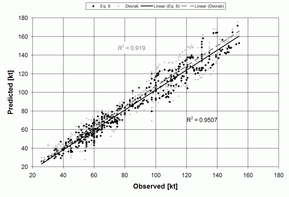
Figure 2: Scatter diagram of the independent predicted values of V max using aircraft pressures with this new methodology shown as black boxes and those predicted using the Dvorak pressure wind relationship (crosses) vs. observed values of V max from the final best track. Click on image to enlarge.
A paper describing the statistical tropical cyclone wind radii prediction schemes used at the National Hurricane Center and the DOD Joint Typhoon Warning Center has been accepted for publication in Weather and Forecasting pending revisions. Two models based on climatology and the persistence of initial conditions are described. One model makes use of parametric vortex to make predictions while the other uses multiple linear regressions. Both produce remarkably similar results. See previous quarterly reports for examples. (J. Knaff)
Verification procedures have been developed and coded for the tropical cyclone wind probability model a Joint Hurricane Testbed project. These procedures were tested using an expanded set of coastal watch/warning points for time periods when hurricane warnings were in place in 2004 and 2005. The verification showed the 64-kt wind probability product is skillful with Brier Skill Scores 26% better than the official deterministic forecast, and a Relative operating characteristics Skill Score of 88%. Further examination of the probabilities showed that they were well calibrated, though they produced a slight under forecast for this dataset. While the warning areas are decreasing and lead times are increasing since 2000, the verification showed that the area warned could be decrease by using the probability model because warnings are often left in place too long, once the threat has diminished (i.e., the probabilities are near 0%). The verification was presented at the Interdepartmental Hurricane Conference in Mobile , AL and the presentation can be viewed at http://www.ofcm.gov/ihc06/Presentations/04%20session4%20JHT/s4-07Knaff_IHC.ppt
Automated routines to clear the cloudy areas from GOES Channel 2 (3.9 um) imagery over a large area of the Tropical Atlantic have been developed. These will be used to create a 5-day SST product to better examine the changes in SSTs in this region. (J. Knaff)
The tropical cyclone maximum intensity climatology for the western North Pacific was reanalyzed using a recently developed wind-pressure relationship. Results indicate that the routine use of the Atkinson and Holliday (1977) wind- pressure relationship has resulted in a substantial intensity bias that can explain much of the climatological intensity trends in this region (Figure 3). This work will be presented at the upcoming AMS 27 th Conference on Hurricane and Tropical Meteorology. Final results as well as an explanation for the observed bias will be submitted to the Journal of Climate . (J. Knaff)
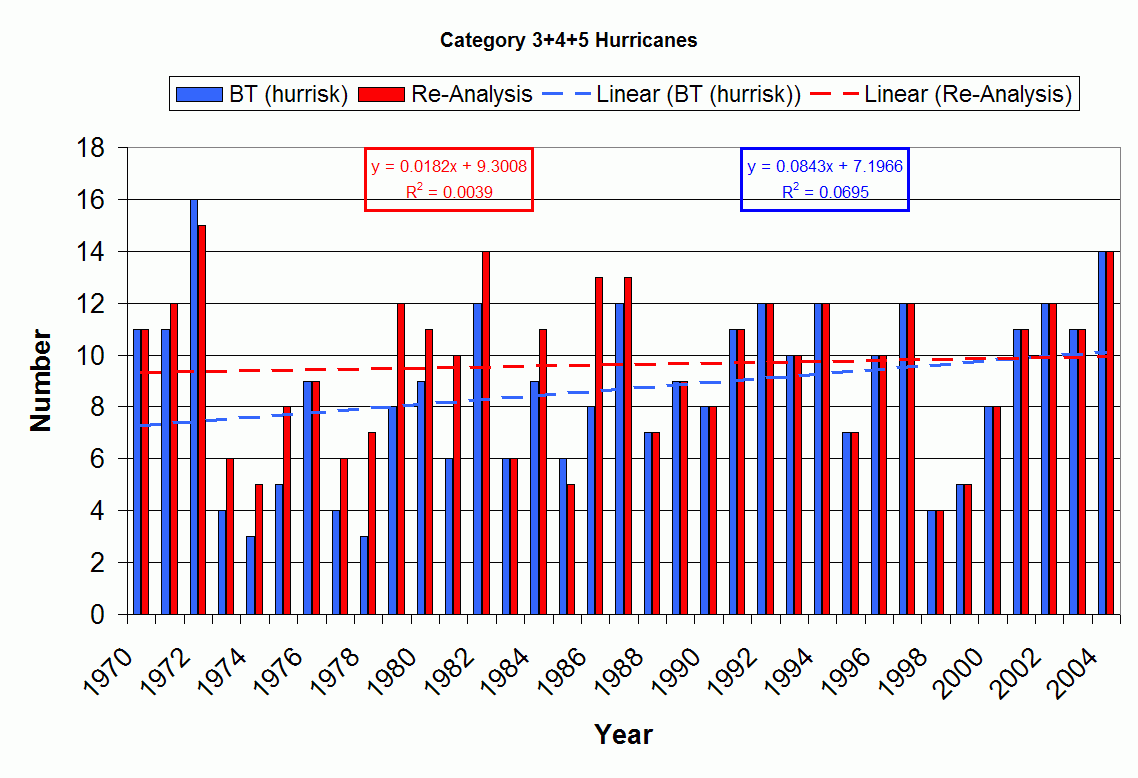
Figure 3. The trend in the number of Safir-Simpson Category 3, 4 and 5 tropical cyclones (i.e., those of major hurricane strength) in the western North Pacific in the Best Track (BT) and following a reanalysis that makes use of the observed MSLP (1966-1987) in a newly developed wind-pressure relationship (reanalysis). Results show that much of the upward trend can be explained by the use of the Atkinson and Holliday wind-pressure relationship (1974-1987), which underestimated the maximum surface winds when aircraft reconnaissance was available.
Data files have been updated with satellite, aircraft, and Best Track information on the seven Atlantic intense hurricanes from 2005. The CIRA version of the Objective Dvorak Technique (ODT) has been run for these seven cases. A draft of a paper, Atlantic Intense Hurricanes Characteristics Based on Satellite, Aircraft, and Best Track Data has undergone internal review, and is being revised to include the 2005 data. (R. Zehr)
A new project documenting a systematic approach to satellite applications for tropical cyclogenesis analysis, is the topic of a conference paper submitted for the upcoming AMS Hurricane Conference, in Monterey , CA. April 24-28, 2006. A case study of Hurricane Rita's pre-tropical storm stages has been completed. (R. Zehr)
![]()
Return to the current RAMM Branch Quarterly Report
RAMMB/CIRA Quarterly Report January February March
2nd Quarter FY06