Mesoscale Research Future Satellite Studies
Programs running on Linux: The McIDAS programs used to create synthetic satellite imagery were successfully run on a Linux machine. They can also be run in a Unix or Windows environment. The ingest of the Advanced Tiros Operational Vertical Sounder (ATOVS) was moved to a Linux machine from a Unix machine. The ATOVS data are being ingested as part of the study of mid latitude cyclones in the northeast Pacific. (J. Dostalek)
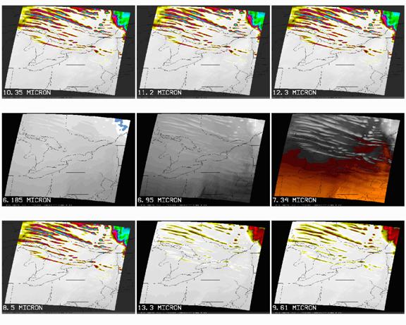
An updated RAMS run was performed to produce synthetic geostationary images of the simulated lake effect snow event of 12 February 2003 and the simulated severe weather event of 8 May 2003. Figures 1 and 2 show the nine simulated infrared wavelengths (~2 km footprint) for a given time of the model runs. This work is part of the GOES-R risk reduction plan. The creation of simulated imagery allows researchers to work with data similar to that which will come from the satellite itself, permitting a jump start to the use of the satellite for mesoscale analysis and forecasting. (L. Grasso, J. Dostalek, and D. Lindsey)
Fig. 1. Synthetic geostationary images at 9 infrared wavelengths from a RAMS simulation of the 12 February 2003 lake effect snow event.

Fig.2. Synthetic geostationary images at 9 infrared wavelengths from a RAMS simulation of the 8 May 2003 severe weather event.
An undesirable feature has been detected in the three simulations that are being used to create synthetic GOESR-ABI imagery. The feature has been fixed and the simulations have been corrected. A new set of synthetic GOESR-ABI images has been produced. (L. Grasso)
An observational operator was used to simulate brightness temperatures from GOES-R's Advanced Baseline Imager (ABI) 6.185 and 10.35 µm channels. The difference between these 2 channels has been observed over deep convection, so this investigation is meant to explain these observations, and to evaluate the utility of such a product when GOES-R is launched. An abstract with results of this study was submitted to the AMS GOES-R Users' Conference (May 2006, Broomfield, CO). (D. Lindsey)
A poster Detecting volcanic ash and blowing dust using GOES, MODIS, and AIRS imagery by B. Connell and F. Prata was presented at the AMS 14th Conference on Satellite Meteorology and Oceanography held in Atlanta, Georgia in January 2006.
An article Preparing for GOES-R: Old Tools with New Perspectives by B. Connell and D. Hillger, was prepared for the spring 2006 edition of the CIRA Magazine. (B. Connell)
![]()
Return to the current RAMM Branch Quarterly Report
RAMMB/CIRA Quarterly Report January February March
2nd Quarter FY06