Severe Storms (Weaver, Dostalek, Grasso, Bikos, Coleman)
The manuscript Noteworthy Aspects of a Severe Left Moving Thunderstorm of 25 May 1999" by J. Dostalek, J. Weaver and L. Phillips (NWS/LBB) has been forwarded, in its final form, to the technical editor at Weather and Forecasting. We are now waiting galley proofs.
A short article entitled Some Frequently Overlooked Visual Severe Thunderstorm Characteristics observed on GOES Imagery a Topic for Future Research by John F. Weaver and Dan Lindsey has been accepted by Monthly Weather Review for inclusion as a Picture of the Month pending responses to minor reviewer comments. The following two figures are from that submission.

Fig. 1. a) schematic of idealized PPI radar reflectivity from a supercell thunderstorm, along with some storm scale features discussed in this paper, and b) schematic of a few cloud features that frequently appear on visible satellite imagery in association with supercell storms.
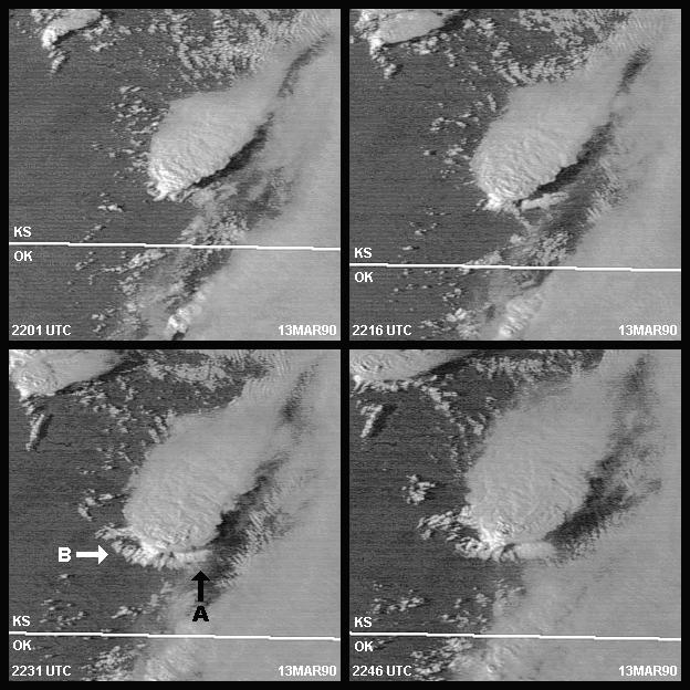
Fig 2. GOES-7 visible satellite imagery from 13 March 1990 showing a storm near Hesston, KS as it transitions from a non-severe thunderstorm to one producing tornadoes and large hail. The phases of this evolution include; (upper-left panel, 22:01 UTC) shows the storm just before the rear flank downdraft (RFD) develops ; (upper-right panel, 22:16 UTC) shows inflow feeder clouds beginning to develop along the southeast flank; (lower-left panel, 22:31 UTC) shows compact inflow feeder clouds associated with the storms intense inflow (arrow A), and cloud lines developing over the invigorated RFD (arrow B); and (lower-right panel 22:46 UTC) shows storm structure at the time an F5 tornado has been on the ground for 12 min.
Work has begun on analyzing cases where satellite imagery was key in
showing returning moisture prior to a severe convective event. The
results of this study will be documented in VISIT training and as a possible
submission to Weather and Forecasting.