DeMaria, Zehr, Hilgendorf, Knaff, Phillips
![]()
A paper documenting a dramatic difference in the thermal structure of two similar looking cyclonic weather systems was submitted to Weather and Forecasting. In this short case study one storm system had tropical origins and a warm core throughout the depth of the troposphere, while the other originated in the subtropics and a very strong warm core in the upper troposphere with a cold core below. The paper is entitled "Temperature structures of two similarly appearing cyclone systems from the Advanced Microwave Sounding Unit." The authors are J. Knaff, R. Zehr, M. Goldberg, and S. Kidder.
Work continues on tropical cyclone convective asymmetries in mature tropical cyclones due to translation and vertical wind shear. Understanding these asymmetries will lead to better interpretation of environmental wind conditions from IR satellite imagery alone.
A rainfall archive has been prepared and software was developed to create hourly rainfall datasets coincident in time and location with 33 hurricanes and 33 tropical storms which made US landfall from 1947-1997. These special datasets are being analyzed in detail in order to gain insight into whether a pattern exists in the relative amount of rainfall measured, with respect to the track of land-falling tropical cyclones. Additional software was developed to sort, display and temporarily archive the results of these analyses.
Super Rapid Scan Operations (SRSO) were requested and the data were archived for the 1999 Hurricane Season. The 1-minute interval images are to be used to derive high density wind sets and analyses of upper core wind fields for use along with aircraft observations to investigate intensity change. This year's data sets were improved due to the capability to define the sector with a latitude-longitude center as opposed to predefined sectors. Unprecedented data coverage was obtained with Hurricane Floyd with SRSO on eight consecutive days capturing most of its life cycle. Other objectives include support of Hurricane Research Division research flights and investigation of cloud patterns within the hurricane eye. SRSO data sets were also archived with Atlantic Hurricanes Bret and Dennis and eastern Pacific Hurricane Dora.
A tropical cyclone genesis experiment, which utilizes the super rapid scan capabilities of the GOES satellites was conducted .in which an SRSO sector will be centered on a targeted developing wave. The high-resolution imagery will be used to create high density wind data sets once a day prior to and during aircraft reconnaissance.
A new project is underway to archive IR images with tropical cyclones in a common format on CD-ROM. Images are saved in MCIDAS format as 4 km resolution Mercator remaps. Image availability is somewhat variable but coverage will be nearly complete for the Atlantic beginning in 1995, and the Eastern Pacific cases beginning in 1997. Best Track data and aircraft reconnaissance observations are to be added. When complete, the archive will contain over 20,000 images.
Research continues on a quantitative assessment of the vertical wind shear forcing on Hurricanes Opal, Bertha, and Erika. The final set of computations are nearly complete and an outline of a paper has been completed. Preliminary analyses of 1999 Hurricanes Bret and Floyd were completed to assess vertical wind shear influences in addition to investigation of minimum sea level pressure maximum wind relationships. Aircraft reconnaisance center fix data were archived for the 1999 flights.
A project continues to document 3 to 6 hour oscillations of deep convection associated with the inner core region of tropical cyclones. This is a new discovery that is in addition to the more commonly known diurnal cycles of deep convection that occur in tropical cyclones and deep oceanic convection. Work is continuing to improve the documentation of this phenomenon with hopes of submitting results for publication next quarter.
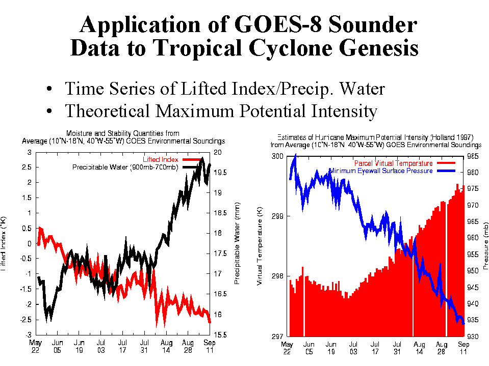
Information concerning the likelihood of tropical cyclone genesis in the tropical Atlantic Ocean is now updated daily and available on the world wide web. Parameters include a measure of zonal vertical wind shear and instability derived from the NCEP Aviation Model Analysis and GOES water vapor brightness temperatures calculated in a box 8 to 18 N and 35 to 55 W. These parameters are combined into a single index that is positive when environmental conditions are favorable for tropical cyclones to form. In addition several parameters related to the probability for tropical Atlantic hurricane activity have been derived solely from the GOES-8 soundings. Parameters include Lifted Index, 900 hPa - 700 hPa precipitable water, Maximum Potential Intensity (given as minimum eyewall pressure), and two experimental thermodynamic genesis potential products. All products are updated daily and are available at: http://www.cira.colostate.edu/ramm/gparm/genesis.asp
Research has begun to create an algorithm based on satellite imagery to predict rapid intensification of hurricanes.