R. Zehr presented a VISITview session on May 21st and May 28th for the Asia-Pacific Satellite Applications Training Course (APSAT) in Australia. There were approximately 40 participants. This VISITview session is an updated version of "Satellite Applications for Tropical Cyclones." It includes some new content, particularly on scatterometer winds and subtropical cyclones. Dan Lindsey, Dan Bikos, and Mark DeMaria at CIRA and Jeff Wilson at Bureau of Meteorology, Melbourne, Australia, provided assistance. M. DeMaria also provided a satellite discussion using real-time data via VISITview for the APSAT course.
D. Bikos and J. Weaver continue development work for two new teletraining sessions - Advanced Lake Effect Snow Prediction, and Applications of GOES-derived Winds.
During this quarter, 66 VISIT teletraining sessions were delivered, 1364 students from 361 NWS offices participated.
New VISIT teletraining that debuted this quarter include: Tornado Warning Guidance 2002 (taught by Jim Ladue of WDTB), Fog Detection and Analysis with Satellite Data (taught by Gary Ellrod of NESDIS), Meteorological Uses of ACARS Data (taught by Rich Mamrosh of NWS Green Bay, WI), Cyclogenesis: Analysis utilizing Satellite Imagery (taught by D. Bikos and J. Weaver)
For a complete list and description of each VISIT session see: http://www.cira.colostate.edu/ramm/visit/ts.html
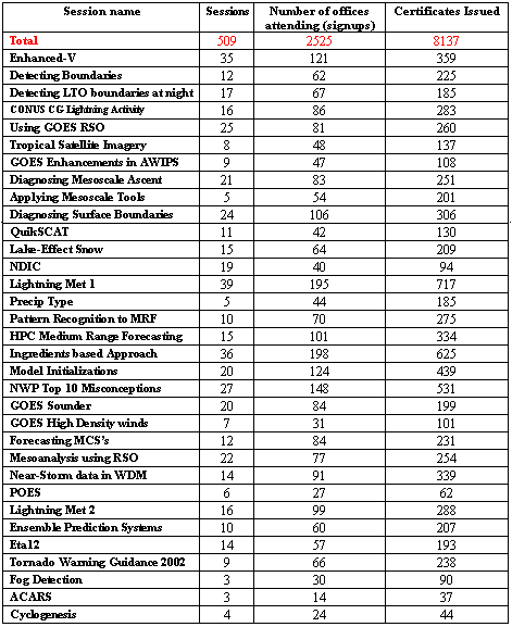
The following list provides a breakdown of the metrics for each VISIT teletraining session valid April 1999 - June 21, 2002.
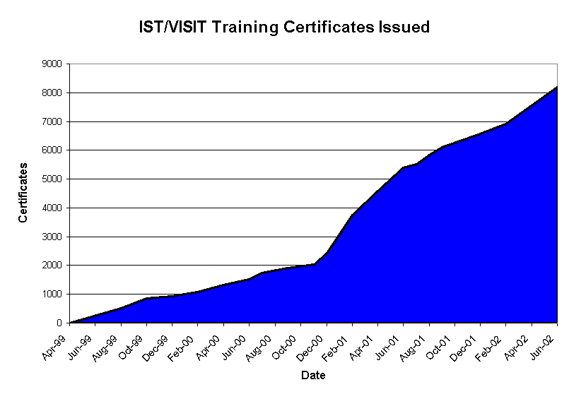
A training certificate of completion is sent out to participants who have returned evaluations. The following graph shows the total number of certificates issued since we started this in April 1999. As of June 21, the total is 8191 certificates.
After each VISIT teletraining session an e-mail is sent out to the focal points with an evaluation. Here is a portion of the evaluation:
Click on image to enlarge
Rate questions #1-9 on a scale of 1 to 5:
1 --> strongly disagree
2 --> disagree
3 --> indifferent
4 --> agree
5 --> strongly agree
If you rate a question as 1 or 2, please discuss why.
1) The session was easy to follow and the objectives were met.
2) The content of the session was appropriate.
3) Teletraining was an appropriate method for presenting the session.
4) The graphics contributed well to my understanding.
5) The instructor provided sufficient interactivity to keep me
involved in the session and test my learning.
6) The instructor explained the material clearly.
7) My knowledge and/or skills increased as a result of this session.
8) The knowledge and/or skills gained through this session are
directly applicable to my job
9) Overall, the session was a good learning experience.
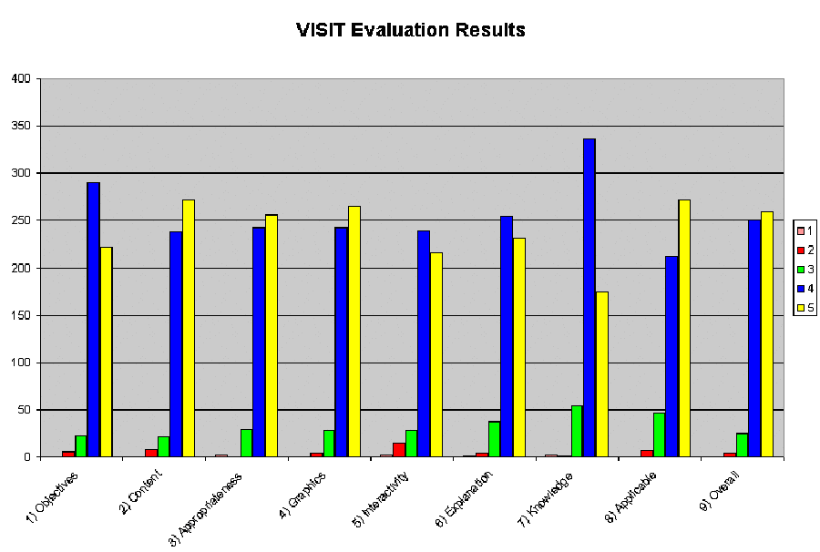
Below is a graph that summarizes these evaluation questions (from December 2000 through the present):
Click on image to enlarge
The graph shows that the vast majority of respondents answered 4 or 5, meaning they responded very positively to the above 9 questions.
Web versions of most VISIT sessions can be found at the following addresses:
Cyclogenesis:
http://www.cira.colostate.edu/ramm/visit/cyclo/title.asp
Boundary Detection:
http://www.cira.colostate.edu/ramm/visit/boundaries1/title.asp
CONUS Cloud to Ground Lightning Climatology:
http://www.cira.colostate.edu/ramm/visit/lightning/title.asp
Convective Initiation by Low-Level Boundaries:
http://www.ssec.wisc.edu/visit/lessons/bndry2/viewmaster.html
Detecting Boundaries:
http://www.cira.colostate.edu/ramm/visit/boundaries1/title.asp
Elevated Mesoscale Ascent:
http://www.cira.colostate.edu/ramm/visit/ascent/title.asp
GOES enhancements/color tables in AWIPS
http://www.cira.colostate.edu/ramm/visit/istpds/awips/awips_1.html
Lake-effect snow (student guide, web based session link temporarily on this page):
http://www.cira.colostate.edu/ramm/visit/les/title.asp
Lightning Meteorology I:
http://www.cira.colostate.edu/ramm/visit/ltgmet1/01_title.asp
Mesoscale Analyses and Techniques:
http://www.cira.colostate.edu/ramm/visit/mesoana/title.asp
NDIC:
http://www.cira.colostate.edu/ramm/visit/ndic/title.asp
Rapid Scan Operations:
http://www.cira.colostate.edu/ramm/visit/rso/title.asp
Tropical Satellite Imagery and Products:
http://www.cira.colostate.edu/ramm/visit/tropical/title.asp
QuikSCAT:
http://www.cira.colostate.edu/ramm/visit/qscat/title.asp
Using AWIPS to Evaluate Model Initializations:
http://www.cira.colostate.edu/ramm/visit/modelinit/title.asp
An Ingredients-Based Methodology for Forecasting Winter Precipitation:
http://www.cira.colostate.edu/ramm/visit/ingredients/title.asp
Precipitation Type Forecasting:
http://www.cira.colostate.edu/ramm/visit/ptype/title.asp
http://www.cira.colostate.edu/ramm/visit/MRF-HPC/title.asp
An Application of Pattern Recognition to Medium Range Forecasting
http://www.cira.colostate.edu/ramm/visit/MRF-pattern/title.asp
Using Near-Storm Environment Data in the WDM Process:
http://www.cira.colostate.edu/ramm/visit/nse/title.asp
The Top Ten Misconceptions of NWP Models:
http://www.cira.colostate.edu/ramm/visit/nwptop10/title.asp
GOES Sounder Data and Products:
http://www.cira.colostate.edu/ramm/visit/sounder/title.asp
http://www.cira.colostate.edu/ramm/visit/goeswinds/title.asp
Mesoscale Analysis using GOES RSO Imagery:
http://www.cira.colostate.edu/ramm/visit/newrso/title.asp
Forecasting Mesoscale Convective Systems:
http://www.cira.colostate.edu/ramm/visit/mcs/title.asp
An Introduction to POES Data and Products:
http://www.cira.colostate.edu/ramm/visit/poes/title.asp
http://www.cira.colostate.edu/ramm/visit/eps/title.asp
What can you expect from the Eta-12?
http://www.cira.colostate.edu/ramm/visit/eta12/title.asp
Fog Detection and Analysis with Satellite Data:
http://www.cira.colostate.edu/ramm/visit/fog/title.asp
Meteorological uses of ACARS data:
http://www.cira.colostate.edu/ramm/visit/acars/title.asp