The recently developed Statistical Typhoon Intensity Prediction Scheme (STIPS) and Decay STIPS were installed, with the assistance of B. Sampson at the Naval Research Laboratory, into the operational suite of products at the Joint Typhoon Warning Center (JTWC), Pearl Harbor, HI. STIPS, which is a statistical model that utilizes forecast synoptic and thermodynamic information along with climatology and persistence to provide 5-day tropical cyclone intensity forecasts in the western North Pacific, was developed under a grant from the Office of Naval Research. The JTWC forecaster, who provides the forecast track to the Automated Tropical Cyclone Forecast System (ATCF), initializes the current version of the model in real-time. An example forecast ATCF dialog display for tropical cyclone 05W valid 17 May at 12 UTC is shown in Fig. 1, the track with forecast intensities is shown in Fig. 2, and the text output in Fig. 3. Along with the installation, training on the use, capabilities, and expectations of the STIPS model was conducted in May of 2002. It is hoped that this model will provide a 10% improvement in tropical cyclone intensity forecasts in the West Pacific tropical cyclone basin.
Click on images to enlarge.
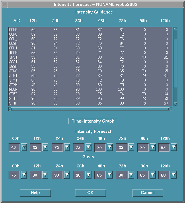
Figure 1: ATCF forecaster dialog valid for tropical cyclone 05W valid on 17 May 12 UTC showing the output of the intensity forecast models available to the forecasters at JTWC at that time. The last two models STIP and STPD are the forecasts produced by the STIPS and decay STIPS model. In operations the forecaster supplies the forecast track and runs the guidance to get an updated set of intensity guidance.
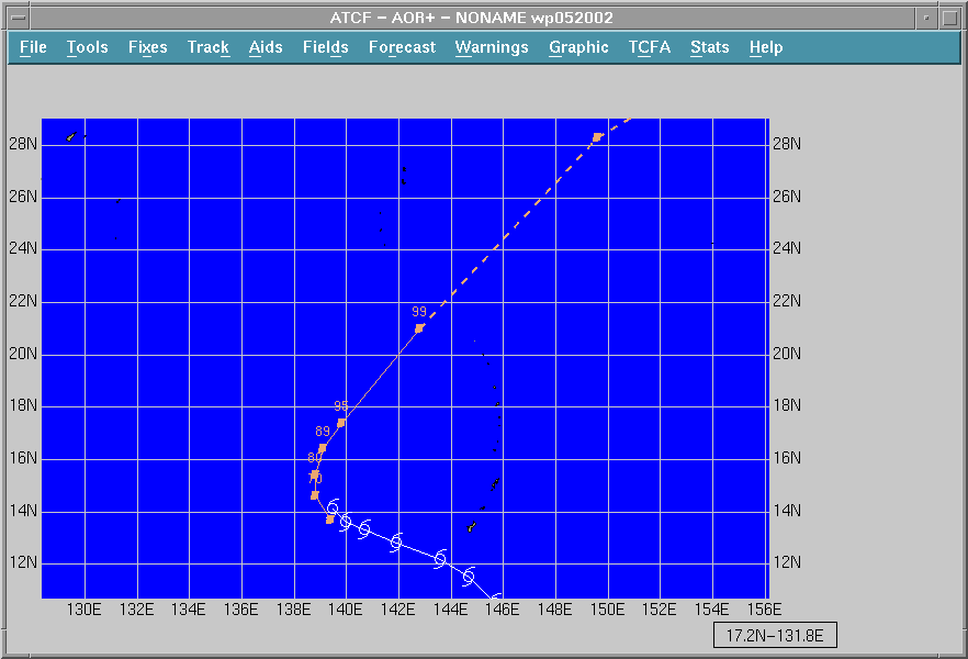
Figure 2: ATCF plot of the track and forecast positions associated with 05W on 17 May 12 UTC with the STIPS intensity forecast overlaying the appropriate forecast positions.
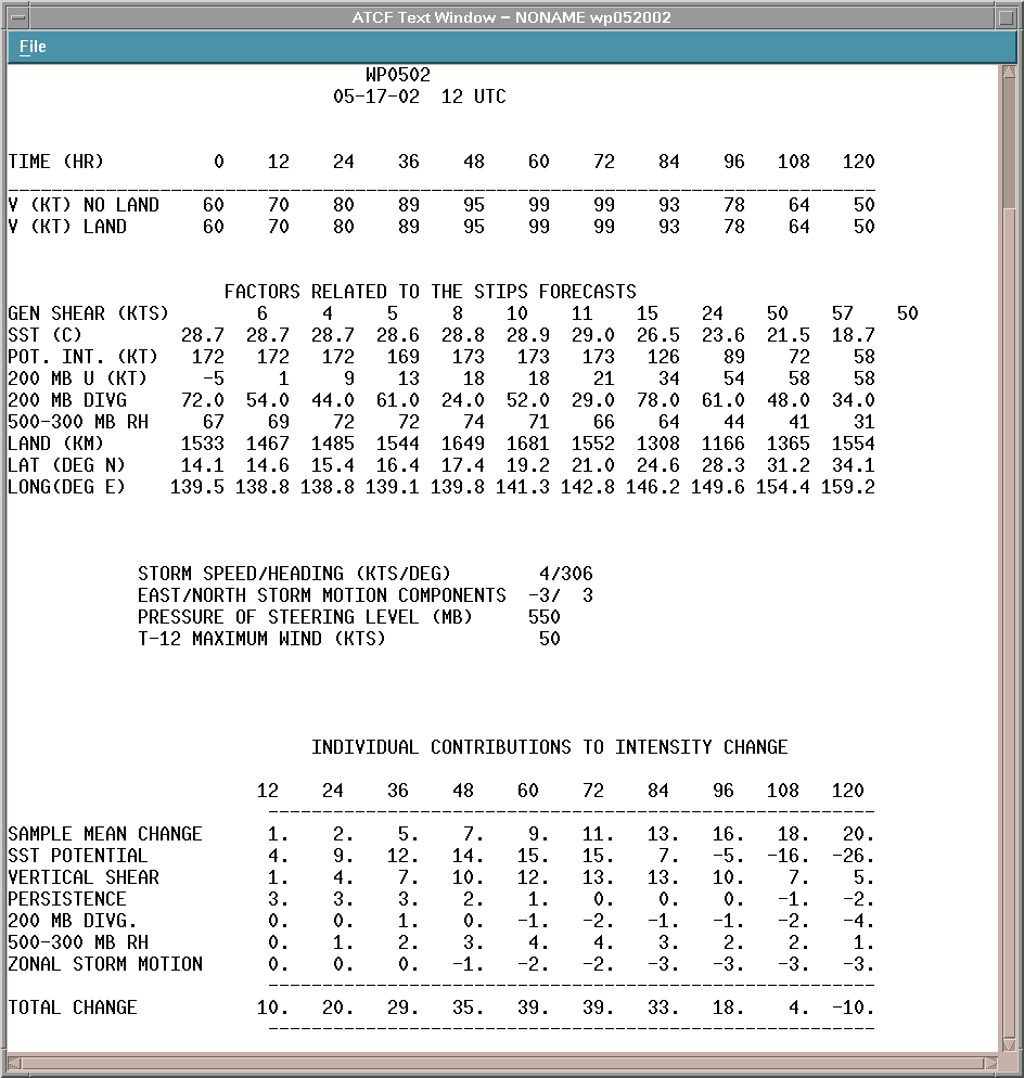
Figure 3: The ATCF text output for 05W 17 May 12 UTC that the forecaster at JTWC receives when he/she runs the STIPS model.
The use of AMSU-A data to estimate tropical cyclone structure and intensity has been made nearly operational as part of the USWRP's Joint Hurricane Test-bed project. Algorithms developed at CIRA to estimate tropical cyclone intensity in terms of pressure and maximum wind and radii of 34, 50 and 64-knot winds have been created and are run in a real-time manner along with the RAMMT web page output. Output from these algorithms is being sent via ftp to forecasters at the National Hurricane Center and the Joint Typhoon Warning Center at synoptic time for their evaluation. An example output is shown in Fig. 4. An independent algorithm for estimating intensity in terms of lowest pressure is being run at our sister Cooperative Institute CIMSS in Wisconsin as part of a real-time comparison exercise in the spirit of the Joint Hurricane Test-bed.
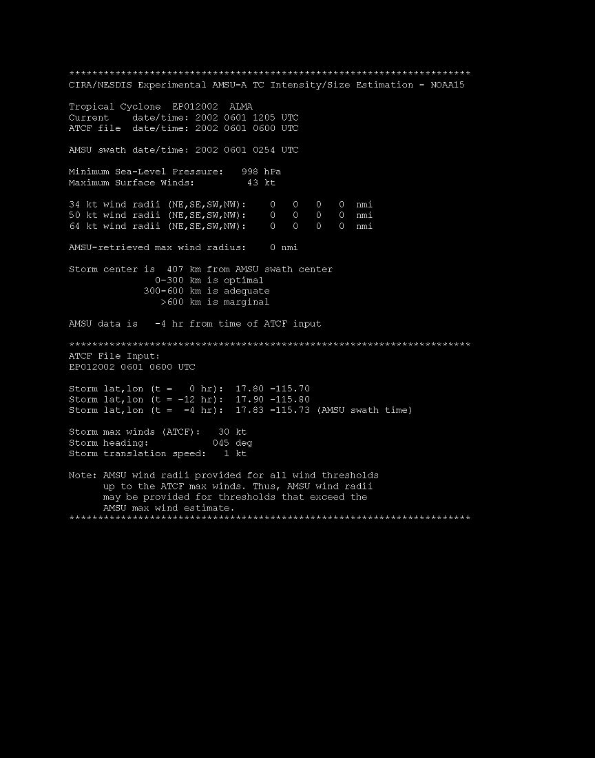
Figure 4: Example output from the CIRA AMSU tropical cyclone structure and intensity algorithms. A similar message is sent to the National Hurricane Center and to the Joint Typhoon Warning Center every 6 hours at synoptic times for each currently active tropical cyclone in the Atlantic, E. Pacific, W. Pacific, Indian Ocean and Southern Hemisphere.
The tropical cyclone genesis potential, originally developed for the tropical eastern Atlantic, has been generalized to include Western Caribbean region. Details of this new regional genesis potential can be seen at:
http://www.cira.colostate.edu/RAMM/gparm/genesis.asp
A manuscript entitled, "Annular Hurricanes" by J. A. Knaff, J. P. Kossin, and M. DeMaria, was reviewed by Weather and Forecasting and is accepted subject to some revision. The paper documents the existence of major hurricanes, which are nearly symmetric with little or little outer rainband activity, and have large eyes, the environment in which they occur and objective method for identifying them in an operational setting. See past quarterly reports for further details.
A manuscript entitled "Statistical, Five-Day Tropical Cyclone Intensity Forecasts Derived From Climatology and Persistence" was reviewed by Weather and Forecasting and accepted subject to some revisions. The paper describes the development and performance of statistical tropical cyclone intensity forecasting models for the Atlantic, eastern North Pacific, and the western North Pacific, which utilized CLImatology and PERsistence (CLIPER) as a basis. CLIPER models are primarily run operationally for evaluation of other forecast models as part of the year-end verification process. These 5-day forecast models replace older 3-day forecast models in the operational suite at the National Hurricane Center and the Joint Typhoon Warning Center as these forecast centers evaluate the issuance of 5-day tropical cyclone forecasts. Independent operational performance of the models in the Atlantic and eastern Pacific basins are comparable to their predecessors (out to 72 hr), while the model developed for the western North Pacific produced forecast that were between 5 and 20% better than its predecessor.
Datasets for studying global tropical cyclones are being collected and archived on a real-time basis. Routine datasets include high-density cloud drift winds, QuikScat winds, hurricane reconnaissance, surface and upper air reports, and AMSU quick look data sets.
A new method for assessing environmental vertical wind shear was tested with Hurricane Erin and Tropical Storm Chantal. The method averages the CIMSS high-density wind vectors in the pressure layer 125-250 hPa, over a 444 km radius circle around the surface center. The tropical cyclone motion vector is then subtracted from the high-level satellite wind vector to obtain a measurement of vertical shear. Preliminary results show reasonable agreement with IR cloud asymmetry and numerical model analysis vertical shear quantities with respect to both direction and magnitude. Additional testing is needed with a larger sample and for comparison with different vertical shear layers. Those results along with IR cloud asymmetry measurements with Hurricane Erin were presented at the AMS Conference on Hurricanes and Tropical Meteorology held in San Diego, April 29- May 2.
A manuscript entitled, "Three Approaches to Quantitative Observations of Environmental Vertical Wind Shear with Hurricane Bertha," has been reviewed for publication in Weather and Forecasting. It has been accepted "with major revision." The paper will be re-submitted in July.
A log of the contents of the tropical cyclone archive was recently updated. Sixty-two tropical cyclones have been added thus far for 2001-2002. This included 21 Southern Hemisphere cases and 10 from the western North Pacific. The archive is complete for the 2001 seasons in the Atlantic and Eastern Pacific with 15 named storms in each basin. The total archive now is comprised of 220 tropical cyclones (149 of hurricane intensity, and 83 that are Saffir-Simpson Category 3 or higher). There are approximately 57,000 MCIDAS images with 4 km resolution on a Mercator projection, which are stored on a set of 32 CDs. This data set continues to be extremely valuable for qualitative and quantitative tropical cyclone analysis.
A study is underway to investigate the effect of satellite spatial resolution on hurricane IR temperature measurements within the eye. The purpose is to study the feasibility of doing temperature retrievals within hurricane eyes with an IR sounder. Simulated sensor resolutions at 4 to 48 km and resultant IR eye temperature measurements from GOES channel 4 imagery were computed for seven Atlantic hurricanes near the time of maximum intensity.
The results suggested three categories of hurricanes according to resolution
needed for representative eye soundings: 1) not well suited for eye
soundings, resolution less than 1 km needed; 2) 1-10 km resolution needed
3) the current GOES sounder resolution of 10 km is adequate.